
Brunei-Muara
| Brunei-Muara | |
|---|---|
  |
|
| Basic data | |
| Country | Brunei |
| Capital | Bandar Seri Begawan |
| surface | 571 km² |
| Residents | 227,300 (2018 census) |
| density | 398 inhabitants per km² |
| ISO 3166-2 | BN-BM |
| Website | bruneimuara.gov.bn (Malay) |
Coordinates: 4 ° 54 ' N , 114 ° 54' E

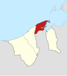
Brunei-Muara is a district ( daerah ) of the Sultanate of Brunei . With an area of 571 square kilometers , it is the smallest, but with 292,705 inhabitants the most populous district in the country. Bandar Seri Begawan , the state capital, is also the capital of the district.
The district borders the South China Sea in the north, Brunei Bay with the Brunei River in the east, the Tutong district in the west and Malaysia in the south.
Economically, the district is heavily dependent on the port of Muara .
Districts
The district is divided into 18 districts ( mukim ):
- Berakas A
- Berakas B
- Burong Pingai Ayer - part of the Kampong Ayer
- Gadong A - until 2007 Gadong
- Gadong B - until 2007 Gadong
- Kianggeh
- Kilanas
- Kota Batu
- Lumapas
- Mentiri
- Pengkalan Batu
- Peramu - part of the Kampong Ayer
- Saba - part of the Kampong Ayer
- Sengkurong
- Serasa
- Sungai Kebun - part of the Kampong Ayer
- Sungai Kedayan - part of the Kampong Ayer
- Tamoi - part of the Kampong Ayer
Individual evidence
Web links
- Official District Brochure (English / Malay)
Belait : Bukit Sawat | Kuala Balai | Kuala Belait | Labi | Liang | Melilas | Seria | Sukang
Brunei-Muara : Berakas A | Berakas B | Gadong A | Gadong B | Kianggeh | Kilanas | Kota Batu | Lumapas | Mentiri | Pengkalan Batu | Sengkurong | Serasa | Burong Pinggai Ayer | Peramu | Saba | Sungai Kebun | Sungai Kedayan | Tamoi
Temburong : Amo | Bangar | Batu Apoi | Bokok | Labu
Tutong : Keriam | Kiudang | Lamunin | Pekan Tutong | Rambai | Tanjong Maya | Telisai | Ukong