Brunei Bay
| Brunei Bay Teluk Brunei |
||
|---|---|---|
|
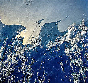
West coast of Borneo with Brunei Bay (left), Kimanis Bay (right) and the offshore island of Pulau Labuan |
||
| Waters | South China Sea | |
| Land mass | Borneo | |
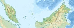
| Geographical location | 5 ° 5 ' N , 115 ° 18' E | |
|
|
||
| width | approx. 45 km | |
| depth | approx. 45 km | |
| surface | 2 500 km² | |
| Coastline | 200 km | |
| Greatest water depth | 30-40 | |
| Islands | Pulau Labuan (in front of the bay), Pulau Alang, Pulau Muara Besar, Pulau badu Kang, Pulau Kingaran, Pulau Chermin | |
| Tributaries | Sungai Brunei , Sungai Padas , Sungai Klias, Sungai Limbang , Sungai Pandaruan, Sungai Lawas | |
The Bay of Brunei or Brunei Bay ( mal. Teluk Brunei ) is a bay on the west coast of the island of Borneo . It belongs to the Malaysian states of Sabah and Sarawak as well as the Sultanate of Brunei and opens to the South China Sea . The bay borders the administrative districts of Brunei-Muara and Temburong on the Brunei side, the Limbang district in Sarawak and the Kuala Penyu , Beaufort and Sipitang districts in Sabah.
geography
The approximately 45 × 45 km large bay covers an area of approximately 2500 km² and extends in north latitude from 4 ° 45 'to 5 ° 2' and in east longitude from 114 ° 58 'to 115 ° 10'. The westernmost extension is marked by Bandar Seri Begawan .
In front of the bay is a series of islands, including Labuan with its distinctive triangular shape. They demarcate the bay from the South China Sea . The more than 200 kilometers long coastline is mainly forested with mangrove swamps.
Flora and fauna
The mangrove forests that occupy large parts of the shore area are home to many threatened species. The dominant mangrove species is Rhizophorae apiculata , which reaches a height of up to 30 m.
The Bay of Brunei is home to a wide variety of fish, e.g. B. ariidae ( Ariidae ) the Catfish Plotosus anguillaris , the commons scat ( Scatophagus Argus ), the Dotted sickle fish ( Drepane punctata ), the Makelenart Indo-Pacific king mackerel , various types of Carangidae (Carangidae) and sardinelles that Anchovisart Coilia dussuinieri , the mullet genera Liza and Mugil as well as rabbit fish ( Siganus ).
Of bird species are found in the Waterside area of American Golden Plover ( Pluvialis dominica ), the Lesser Sand Plover ( Charadrius mongolus ), the Whimbrel ( Numenius phaeopus ), the redshank ( Tringa totanus ), the Terek Sandpiper ( Xenus cinereus ), the Sandpiper ( Actitis hypoleucos ) and the Gray-tailed tattler ( Heteroscelus brevipes ).
The mangrove forests are home to a significant population of the proboscis monkey ( Nasalis larvatus ), the cap langur ( Presbytis sp.) And the Kalong flying fox ( Pteropus vampyrus ).
A total of eleven species of shrimp live in the bay, three of which - Penaeus merguiensis , Penaeus indicus and Metapenaeus brevicornis - are commercially fished.
literature
- Sailing Directions (Enroute) - Borneo, Jawa, Sulawesi and NUsa Tenggara (PDF; 5.8 MB) United States Navy Publication 163, pages 331–341, 2002
- International Water Management Institute (IWMI): Brunei Darussalam (PDF; 96 kB)
Individual evidence
- ^ Administrative District Boundary and Local Authority Area . In: Census 2010 for Sabah ( Memento of the original from November 14, 2013 in the Internet Archive ) Info: The archive link was inserted automatically and has not yet been checked. Please check the original and archive link according to the instructions and then remove this notice. (PDF; 1.9 MB) Statistical Office, Malaysia, p. 153.
- ^ IWMI report Brunei Darussalam , page 5
- ↑ a b c d IWMI report Brunei Darussalam , page 7

