
Sungai Padas
| Padas | ||
 Padas between Beaufort and Tenom |
||
| Data | ||
| location | Sabah , Borneo , Malaysia | |
| River system | Padas | |
| source | in southwest Sabah | |
| muzzle |
South China Sea Coordinates: 5 ° 11 ′ 8 " N , 115 ° 33 ′ 50" E 5 ° 11 ′ 8 " N , 115 ° 33 ′ 50" E
|
|
| Catchment area | 7720 km² | |
| Left tributaries | Sungai Pegalan , Sungai Pangi, Sungai Ketanum, Sungai Meligan, | |
| Right tributaries | Sungai Sunghi, Sungai Tomani, Pa Nagas | |
| Small towns | Tenom , Beaufort | |
| Water level in Tenom: 5 ° 7 ′ 0 ″ N , 115 ° 55 ′ 50 ″ E | ||
 Padas with source and tributaries (dark blue coloring) |
||
The Padas ( mal. Sungai Padas ) or Padas River is a river in the Malaysian state of Sabah on Borneo . It rises in southwestern Sabah, in the border area with Indonesia and Sarawak and runs from the highlands to the mouth at Weston in the Padas Bay, which in turn belongs to the South China Sea . The river meanders strongly in the estuary . The Padas with its source and tributaries drains an area of 7720 km².
geology
About 20% of the catchment area consists of alluvial soils at altitudes between 200 and 600 m, another 60% of hills and 20% of mountains with altitudes up to 2600 m. Sandy loam, sediments and fine to coarse-grained sands predominate. The south and east consist of sandstone and mudstone, the west of silt slate and solid sandstone, the north of alluvial gravel. 22% of the water volume of the Sungai Pada comes from the catchment area of the Sungai Sook and flows to the Padas via the Sungai Pegalan.
use
The Padas with its headwaters and tributaries is the largest river system in the west of Sabah. The lower reaches the districts of Beaufort and Tenom as well as the federal territory of Labuan . In addition, in a barrage below Tenom, electricity is generated from hydropower for the west coast of Sabah.
Between Tenom and Beaufort , the river runs in the Padas Gorge. This stretch of the river is popular for white water rafting and kayaking . In addition, the Sabah State Railway follows the course of the river. For the canyon residents, the railway is the only infrastructural connection between single houses and settlements in the roadless Padas Valley.
gallery
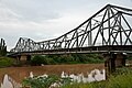
Bridge over the Sungai Padas in Beaufort
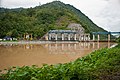
Barrage near Tenom at the entrance to the Padas Gorge
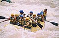
White water rafting in the Padas Gorge


Individual evidence
- ↑ a b Ministry of Natural Reserves and Environment: Average Annual Surface Water Resources of Sabah and sarawak (PDF; 69.6 MB); Water Resources Publications N °. 15; P. 33, 1984.
- ^ A b Maria Seda: Environmental management in ASEAN: perspectives on critical regional issues. Institute of Southeast Asian, Singapore 1993, ISBN 981-3016-44-2 , p. 137 ( books.google.de ).
- ↑ Field Site Description of Sook Plain ( page no longer available , search in web archives ) Info: The link was automatically marked as defective. Please check the link according to the instructions and then remove this notice.
- ^ Ministry of Culture, Environment and Tourism: Ulu Padas - Final Report (PDF; 259 kB), 1998; Accessed January 24, 2012.