
Temburong (District)
| Temburong | |
|---|---|
  |
|
| Basic data | |
| Country | Brunei |
| Capital | Bangar |
| surface | 1166 km² |
| Residents | 10,900 (2018 estimate) |
| density | 9.3 inhabitants per km² |
| ISO 3166-2 | BN-TE |
Coordinates: 4 ° 36 ' N , 115 ° 12' E

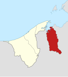
Temburong is the easternmost district ( Daerah ) of the Sultanate of Brunei with 10,900 inhabitants (2018 estimate) on an area of 1166 km². The district is bounded by Brunei Bay in the north and Malaysia ( Trusan District of Sarawak State ) in the east, south and west. It thus represents a fake exclave that is separated from the western part of Brunei, but can be reached from the mainland via the sea by ship - and since 2019 via the Temburong Bridge .
The capital is Bangar ; another large town is Labu .
The Temburong and Pandaruan rivers flow through the district , the latter forming the eastern border with Malaysia.
The population consists largely of Malays and indigenous people such as Murut , Kadayan and Iban , some of whom still practice shifting cultivation . Due to its location, separated from the motherland of Brunei and the low population density, Temburong is considered the most backward district of Brunei.
structure
Temburong is divided into five districts ( mukim ) : Amo , Bangar , Batu Apoi , Bokok and Labu . At the lowest administrative level, these are divided into a total of 75 kampung (villages).
tourism
Until March 2020, Temburong could only be reached by ship from the capital of Brunei. The crossing took about 45 minutes.

In Temburong you can see traditional longhouses of the indigenous Dayak people as well as numerous animal species such as crocodiles and monkeys. Especially worth seeing are:
- the Ulu-Temburong National Park with the largest continuous primary forest on Borneo
- the Batang Duri Park on the Temburong River
- the Batu Apoi forest reserve, which covers approximately 500 square kilometers, with a center for field studies of the tropical rainforest (Rainforest Field Studies Center)
- the Peradayan Recreation Park
- the 410 meter high Bukit Peradayan
- the 310 meter high Bukit Petoi with a panoramic view of the South China Sea
Web links
- Official Brochure (English / Malay)
Individual evidence
- ↑ population. Ministry of Finance and Economy, accessed June 3, 2019 .
- ↑ a b c d e Jatswan S. Sidhu: Historical dictionary of Brunei Darussalam . Rowman & Littlefield, Lanham 2017, ISBN 978-1-4422-6458-8 , pp. 301 .
Belait : Bukit Sawat | Kuala Balai | Kuala Belait | Labi | Liang | Melilas | Seria | Sukang
Brunei-Muara : Berakas A | Berakas B | Gadong A | Gadong B | Kianggeh | Kilanas | Kota Batu | Lumapas | Mentiri | Pengkalan Batu | Sengkurong | Serasa | Burong Pinggai Ayer | Peramu | Saba | Sungai Kebun | Sungai Kedayan | Tamoi
Temburong : Amo | Bangar | Batu Apoi | Bokok | Labu
Tutong : Keriam | Kiudang | Lamunin | Pekan Tutong | Rambai | Tanjong Maya | Telisai | Ukong