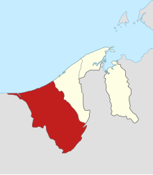
Belait (district)
| Belait | |
|---|---|
| Basic data | |
| Country | Brunei |
| Capital | Kuala Belait |
| surface | 2727 km² |
| Residents | 63,200 (2018 census) |
| density | 23 inhabitants per km² |
| ISO 3166-2 | BN-BE |
| Website | belait.gov.bn (MALAY) |
Coordinates: 4 ° 30 ' N , 114 ° 30' E
Belait is a district ( Daerah ) of the Sultanate of Brunei . With an area of 2,727 km² it is the largest and with a population of 69,992 (as of 2016) the second most populous of the four Brunei districts. The capital of Belait is Kuala Belait .
Belait is located in western Brunei on the border with Malaysia . The district capital Kuala Belait is about 120 km away from the capital Bandar Seri Begawan . The Belait , the longest river in Brunei, flows through the district .
Education and economy
St. Margaret's School is located in the district .
Belait, and the town of Seria in particular , are the heart of Brunei's oil and natural gas industry . There are two oil and gas fields on land: the Seria Oil Field (discovered in 1929) and the smaller Rasau Field . A little further from the coast are the offshore fields South-West Ampa , Fairley , Fairley baram and Egret fields .
Population development
| 1947 | 1971 | 1981 | 1991 | 2001 | 2011 | 2016 |
|---|---|---|---|---|---|---|
| 12 567 | 42 400 | 50 768 | 52 957 | 55 602 | 60 744 | 69 992 |
Administrative division
The Belait district is divided into eight districts ( mukim ):
literature
- Peter W. Martin: Sociohistorical Determinants of Language Shift among the Belait Community in the Sultanate of Brunei . In: Anthropos. Internationale Zeitschrift für Völker- und Sprachenkunde , Vol. 91 (1996), pp. 199–207.
Web links
- Official Brochure (English / Malay)
Individual evidence
- ↑ sheet T2
- ↑ http://www.information.gov.bn/PublishingImages/SitePages/Publication%20Lists/BelaitDistrict.pdf
- ↑ a b Belait District. Borneo tour. Retrieved April 1, 2019.
- ^ Brunei: Districts & Cities - Population Statistics, Maps, Charts, Weather and Web Information. Retrieved May 16, 2018 .


