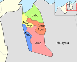
Bokok
| Mukim Bokok Bokok |
||
|---|---|---|
|
|
||
| Coordinates | 4 ° 39 ′ N , 115 ° 3 ′ E | |
| Basic data | ||
| Country | Brunei | |
| Temburong | ||
| ISO 3166-2 | BN-TE | |
| surface | 136 km² | |
| Residents | 3583 (2016) | |
| density | 26.3 Ew. / km² | |
|
The Mukim of Temburong
|
||
Bokok ( Malay Mukim Bokok , also: Bukok) is a Mukim in the Temburong district of Brunei . The Mukim has an area of 136 km²; and 2016 approx. 3,600 inhabitants.
geography
Bokok is the westernmost sub-district of Temburong and is bounded to the west by the Malaysian state of Sarawak . The steep hills of the Limbang Syncline form the natural boundary in the northwest. To the north and west, the Mukim borders on the Brunei Mukim Bangar and Amo . In the northeast, the Temburong (approximately to Batang Duri ) forms part of the border.
Administrative division
Mukim Bokok is divided into the Kampong (villages):
- Kampong Buda-Buda
- Kampong Belais
- Kampong Belais Kecil
- Kampong Paya Bagangan
- Kampong Bokok
- Kampong Meniup
- Kampong Bakarut
- Kampong Simbatang
- Kampong Rataie
- Kampong Perpindahan Rataie
- Kampong Rakyat Jati
- Kampong Kenua
- Kampong Lepong Baru
- Kampong Lepong Lama
- Kampong Semabat Bahagia
- Kampong Semabat
- Kampong Temada
Individual evidence
- ↑ Jabatan Daerah Temburong, Kementerian Hal Ehwal Dalam Negeri - MUKIM BOKOK ( ms )
- ↑ Data Set Population Temburong Population by Mukims (XLSX) ( page no longer available , search in web archives ) Info: The link was automatically marked as defective. Please check the link according to the instructions and then remove this notice.
- ↑ researchgate.net.

