Labu (Brunei)
| Mukim Labu Labu |
||
|---|---|---|
|
|
||
| Coordinates | 4 ° 47 ' N , 115 ° 10' E | |
| Basic data | ||
| Country | Brunei | |
| Temburong | ||
| ISO 3166-2 | BN-TE | |
| surface | 600 km² | |
| Residents | 2696 (2016) | |
| density | 4,5 Ew. / km² | |
|
The Mukim of Temburong
|
||
Labu is a Mukim in the Temburong District of Brunei . The Mukim (sub-district) covers 292 km² and in 2016 had about 600 inhabitants.
geography
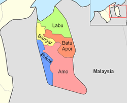
Labu is located in the north of the Temburong district on the coast of Brunei Bay . It borders on Sarawak ( Malaysia ) in the east , the Mukim Batu Apoi in the south and the Mukim Bangar in the southwest, and Limbang , Sarawak (Malaysia) in the west. The Mukim contains several islands: Pulau Selirong , Pulau Selanjak , Pulau Siarau and Pulau Pituat . It is named after the Sungai Labu , which forms part of the southern border. There are numerous estuaries on the coast , including Sungai Raya ( ⊙ ), Alor Besar ( ⊙ ), Sungai Melimbai ( ⊙ ), Sungai Ayam Ayam ( ⊙ ), Sungai Berbunga ( ⊙ ), Sungai Bontu Kechil ( ⊙ ), Sungai Duau Besar ( ⊙ ), Sungai Lawang ( ⊙ ).
Administrative division
Labu is divided into the Kampong (settlements)
- Kampong Labu Estate
- Kampong Senukoh
- Kampong Piasau-Piasau
- Kampong Payau
- Kampong Ayam-Ayam
Much of the area belongs to the Labu Forest Reserve and the northern tip (Pulau Selirong) is separately designated as Selirong Recreational Park .
Border crossings
Border crossings to Sarawak, Malaysia can be reached via Bangar and Lawas . The so-called Labu Checkpoint is located east of Bangar. The Malaysian checkpoint is called Mengkalap .

