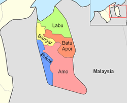
Batu Apoi
| Mukim Batu Apoi Batu Apoi |
||
|---|---|---|
|
|
||
| Coordinates | 4 ° 41 ′ N , 115 ° 12 ′ E | |
| Basic data | ||
| Country | Brunei | |
| Temburong | ||
| ISO 3166-2 | BN-TE | |
| surface | 222 km² | |
| Residents | 1600 (2016) | |
| density | 7.2 Ew. / km² | |
|
The Mukims of Temburong
|
||
Batu Apoi is a mukim in the Temburong district of Brunei . The Mukim (sub-district) covers 222 km² and in 2016 had about 1,600 inhabitants.
geography
The Mukim is located in the east of the Temburong district and extends to the west in its center. It borders with Mukim Labu in the north, Sarawak ( Malaysia ) in the east, Mukim Amo in the south and Mukim Bangar in the west. The western part of the Mukim extends along the rise of the Limbang Syncline from the coast to the north. The name of the Mukim is derived from the Sungai Batu Apoi , which rises south of the Limbang Syncline, breaks through the range of hills at Lamaling and flows into the Temburong at Kampong Labut (Labu) ( ⊙ ). A large part of the area is now under conservation and belongs to the Peradayan Forest Reserve .
Administrative division
Batu Apoi includes the settlements
- Kampong Batu Apoi
- Kampong Sungai Radang
- Kampong Peliunan
- Kampong Sungai Bantaian
- Kampong Gadong Baru
- Kampong Luagan
- Kampong Negalang Iring
- Kampong Negalang Unat
- Kampong Lakiun
- Kampong Tanjong Bungar
- Kampong Lamaling
- Kampong Selapon
- Kampong Sekurop

