Amo (Brunei)
| Mukim Amo Amo |
||
|---|---|---|
|
|
||
| Coordinates | 4 ° 36 ′ N , 115 ° 8 ′ E | |
| Basic data | ||
| Country | Brunei | |
| Temburong | ||
| ISO 3166-2 | BN-TE | |
| surface | 542 km² | |
| Residents | 2240 (2016) | |
| density | 4.1 Ew. / km² | |
|
The Mukims of Temburong
|
||
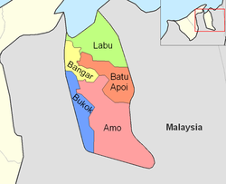
Amo ( Malay Mukim Amo ) is a Mukim (sub-district) in the Temburong district of Brunei . The Mukim has about 2,240 inhabitants (2016) and is subordinate to a Penghulu . The incumbent is currently Bahrun bin Talib .
geography
Amo is located in the southeast part of the district and its eastern border forms a large part of the eastern border of Brunei and Malaysia ( Sarawak ), to the west the Mukim Bokok joins and to the north the Mukim Batu Apoi (NE) and Bangar (NW). The Malaysian state of Sarawak surrounds the area in the east and south. Amo has an area of 542 km²; Unlike the northern areas of Brunei, the predominant rocks in Amo come from the Oligocene . The majority of the area belongs to the Ulu Temburong National Park and on the southern border is the Bukit Pagon , at 1850 m the highest mountain in Brunei, where a source river of the Temburong rises.
administration
Amo is officially divided into 12 so-called Kampung:
- Amo 'A'
- Amo 'B'
- Amo 'C'
- Batang Duri
- Belaban
- Biang
- Parit
- Selangan
- Sibulu
- Sibut
- Sumbiling Lama
- Sumbiling Baru
These areas are divided by the Survey Department and the Postal Services Department , so each area has its own zip code. The Temburong District Office , which manages the Kampung, only manages four areas as a village institution, namely Amo, Sumbiling, Sibut and the community area Selangan, Parit and Biang . Each of these "villages" has its own mayor ("ketua kampung") and is responsible for certain tasks. The Temburong District Office reports to the Ministry of Home Affairs .
Individual evidence
- ↑ Data Set Population Temburong Population by Mukims (XLSX)
- ↑ a b c d Jabatan Daerah Temburong, Kementerian Hal Ehwal Dalam Negeri - MUKIM AMO ( ms )
- ↑ Brunei Postal Services - postcodes ( en )

