Aringay
| Municipality of Aringay | ||
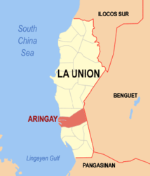
| Location of Aringay in the province of La Union | ||
|---|---|---|

|
||
| Basic data | ||
| Region : | Ilocos region | |
| Province : | La Union | |
| Barangays : | 24 | |
| District: | 2. District of La Union | |
| PSGC : | 013302000 | |
| Income class : | 2nd income bracket | |
| Households : | 8435 May 1, 2000 census
|
|
| Population : | 47,458 August 1, 2015 census
|
|
| Population density : | 388.8 inhabitants per km² | |
| Area : | 122.07 km² | |
| Coordinates : | 16 ° 23 ′ N , 120 ° 25 ′ E | |
| Postal code : | 2503 | |
| Mayor : | Teresita A. Ong | |
| Website: | www.aringay.gov.ph | |
| Geographical location in the Philippines | ||
|
|
||
Aringay is a municipality on the Gulf of Lingayen in the Philippine province of La Union . In the east it borders on the province of Benguet .
climate
The city in the north of Luzón has a typical monsoon climate with a dry season from November to April and a rainy season from May to October.
economy
The people of Aringay live mainly from growing rice , fruit and tobacco . Few of them make a living from tourism.
history
Aringay is an ancient place and was known as Alingay or Alinguey even before the colonial era . When the Spanish settlers arrived in Aringay in the late 16th century, they found pangasináns trading with the Ilocanos and the Ifugaos . They also had contact with dealers from China , Japan and Southeast Asia . The community was eventually part of the Spanish colonies and the Augustinians evangelized the population to the Roman Catholic faith.
Aringay remained part of Pangasinan Province until April 18, 1854 . Then the northern area of the province and the southern areas of Ilocos Sur were united, creating the new province of La Union . In the 18th and 19th centuries more and more Ilocanos moved south and at the end of the 19th century it was mainly Ilocanos who lived in Aringay.
The city was subject to repeated uprisings during the four centuries of rule of the Spaniards, Americans and Japanese. Bloody confrontations were started by revolutionaries such as Diego Silang and Gabriela Silang during the Spanish occupation. This was later followed by rebel uprisings in the Philippine-American War and the Japanese destroyed the rural barangays of Aringay during World War II .
A decisive battle took place on the Aringay River when American troops crushed the Ilocano partisans. From 1901 onwards, the province of La Union was finally in the hands of the Americans.
The Japanese attacked Aringay in December 1941 and brutally executed many Aringayenos during their retreat from 1945 to 1946.
Barangays
Aringay is divided into the following 24 barangays :
|
|
