Barthos
|
Barthos Ruisseau de Barthos |
||
|
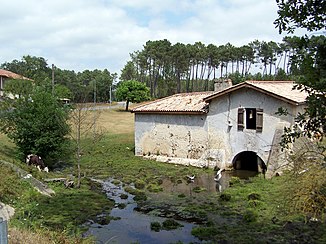
Moulin de Muset - Mill on the riverside |
||
| Data | ||
| Water code | FR : O9540500 | |
| location | France , Nouvelle-Aquitaine region | |
| River system | Garonne | |
| Drain over | Ciron → Garonne → Atlantic Ocean | |
| source | on the municipal boundary of Saint-Martin-Curton and Antagnac 44 ° 20 ′ 56 ″ N , 0 ° 0 ′ 56 ″ W |
|
| Source height | approx. 143 m | |
| muzzle | on the municipal boundary of Cudos and Lerm-et-Musset in the Ciron coordinates: 44 ° 20 ′ 48 ″ N , 0 ° 12 ′ 49 ″ W 44 ° 20 ′ 48 ″ N , 0 ° 12 ′ 49 ″ W |
|
| Mouth height | approx. 63 m | |
| Height difference | approx. 80 m | |
| Bottom slope | approx. 3.5 ‰ | |
| length | approx. 23 km | |
The Barthos is a river in France that runs in the Nouvelle-Aquitaine region . It rises under the name Ruisseau de Labarthe on the municipal boundary of Saint-Martin-Curton and Antagnac , generally drains in a westerly direction and flows into the Ciron as a right tributary after about 23 kilometers at the municipal boundary of Cudos and Lerm-et-Musset . On its way, the Barthos crosses the Lot-et-Garonne and Gironde departments .
Places on the river
- Bon Loc , municipality of Sillas
- Le Barthos , parish of Marions
- Moulin de Muset , Lerm-et-Musset
- Agnaoutoun , municipality of Lerm-et-Musset
