
Lerm-et-Musset
|
Lerm-et-Musset L'Èrm e Musset |
||
|---|---|---|
|
||
| region | Nouvelle-Aquitaine | |
| Department | Gironde | |
| Arrondissement | Langon | |
| Canton | Le Sud-Gironde | |
| Community association | Bazadais | |
| Coordinates | 44 ° 20 ′ N , 0 ° 9 ′ W | |
| height | 64-137 m | |
| surface | 36.87 km 2 | |
| Residents | 482 (January 1, 2017) | |
| Population density | 13 inhabitants / km 2 | |
| Post Code | 33840 | |
| INSEE code | 33239 | |
| Website | http://lermetmusset.fr/z/index.php | |
 Town hall (Mairie) of Lerm-et-Musset |
||

Lerm-et-Musset ( L'Erm e Musset on gascognisch ) is a French municipality with 482 inhabitants (as of January 1 2017) in the Gironde department in the region Nouvelle-Aquitaine (before 2016: Aquitaine ). The municipality belongs to the arrondissement of Langon and the canton of Le Sud-Gironde (until 2015: canton of Grignols ). The inhabitants are called Lermois .
geography
Lerm-et-Musset is located 65 kilometers southeast of Bordeaux and about 26 kilometers south-southeast of Langon . The Barthos river runs along the northern boundary of the municipality . Lerm-et-Musset is surrounded by the neighboring communities of Cudos in the north, Lavazan in the northeast, Marions in the east and northeast, Goualade in the south and east and Escaudes in the west.
Population development
| year | 1962 | 1968 | 1975 | 1982 | 1990 | 1999 | 2006 | 2013 |
|---|---|---|---|---|---|---|---|---|
| Residents | 529 | 454 | 400 | 360 | 360 | 399 | 444 | 488 |
| Source: Cassini and INSEE | ||||||||
Attractions
See also: List of Monuments historiques in Lerm-et-Musset
- Notre-Dame church in Lerm
- Church ruins Saint-Martin in Musset
- Old watermill at Ruisseau de Barthos

Notre-Dame church in Lerm
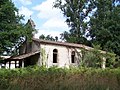
Saint-Martin church ruins

Old watermill


literature
- Le Patrimoine des Communes de la Gironde. Flohic Éditions, Volume 1, Paris 2001, ISBN 2-84234-125-2 , pp. 753-754.