
Saint-Pardon-de-Conques
| Saint-Pardon-de-Conques | ||
|---|---|---|
|
||
| region | Nouvelle-Aquitaine | |
| Department | Gironde | |
| Arrondissement | Langon | |
| Canton | Le Sud-Gironde | |
| Community association | South Gironde | |
| Coordinates | 44 ° 33 ′ N , 0 ° 11 ′ W | |
| height | 0-54 m | |
| surface | 6.68 km 2 | |
| Residents | 579 (January 1, 2017) | |
| Population density | 87 inhabitants / km 2 | |
| Post Code | 33210 | |
| INSEE code | 33457 | |
| Website | st-pardon-de-conques.fr | |
 Town hall (Mairie) of Saint-Pardon-de-Conques |
||

Saint-Pardon-de-Conques is a French municipality with 579 inhabitants (as of January 1 2017) in the department of Gironde in the region Nouvelle-Aquitaine . It belongs to the canton of Le Sud-Gironde in the Arrondissement of Langon and is a member of the Sud Gironde community association . The inhabitants are called Perdonnais .
geography
Saint-Pardon-de-Conques is located about 52 kilometers southeast of Bordeaux on the Garonne . Saint-Pardon-de-Conques is surrounded by the neighboring communities of Saint-Pierre-d'Aurillac in the north, Castets et Castillon in the east and northeast, Saint-Loubert in the east, Bieujac in the southeast, Auros in the south and southeast and Saint-Pierre- de-Mons to the west.
Population development
| year | 1962 | 1968 | 1975 | 1982 | 1990 | 1999 | 2006 | 2013 |
| Residents | 247 | 197 | 189 | 235 | 361 | 393 | 497 | 562 |
| Source: Cassini and INSEE | ||||||||
Attractions
- Saint-Pardon church from the 11th / 12th centuries century
- Les Jaubertes castle from the 16th / 17th centuries Century, since 1978 Monument historique
- Le Salin pigeon tower
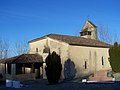
Saint-Pardon church

Les Jaubertes castle

Le Salin pigeon tower


literature
- Le Patrimoine des Communes de la Gironde. Flohic Éditions, Volume 2, Paris 2001, ISBN 2-84234-125-2 , pp. 848-851.