
Saint-Ferme
|
Saint-Ferme Sent Fèrmer |
||
|---|---|---|
|
||
| region | Nouvelle-Aquitaine | |
| Department | Gironde | |
| Arrondissement | Langon | |
| Canton | Le Réolais and Les Bastides | |
| Community association | Rurales de l'Entre-Deux-Mers | |
| Coordinates | 44 ° 47 ′ N , 0 ° 2 ′ W | |
| height | 30-126 m | |
| surface | 20.09 km 2 | |
| Residents | 349 (January 1, 2017) | |
| Population density | 17 inhabitants / km 2 | |
| Post Code | 33580 | |
| INSEE code | 33400 | |
 Town hall (Mairie) of Saint-Ferme |
||

Saint-Ferme ( Occitan Sent FERMER ) is a French municipality with 349 inhabitants (as of January 1 2017) in the Gironde department in the region Nouvelle-Aquitaine . It belongs to the Arrondissement of Langon and the canton of Le Réolais et Les Bastides . The inhabitants are called Saint-Fermois .
geography
Saint-Ferme is located about 51 kilometers east-southeast of Bordeaux . Saint-Ferme is surrounded by the neighboring communities of Cazaugitat in the north and north-west, Auriolles in the north, Pellegrue in the north and north-east, Dieulivol in the east and south-east, Le Puy in the south, Coutures in the south and south-west and Rimons in the west and south-west.
The Via Lemovicensis , one of the four historical " Paths of the St. James pilgrims in France " , runs through the municipality .
Population development
| 1962 | 1968 | 1975 | 1982 | 1990 | 1999 | 2006 | 2017 |
|---|---|---|---|---|---|---|---|
| 548 | 505 | 404 | 382 | 369 | 338 | 353 | 349 |
| Sources: cassini and INSEE | |||||||
Attractions
- Monastery of Saint-Ferme, documented for the first time in the 6th century, founded as a Benedictine monastery in 1080, later fortification, monument historique since 1990, with church
See also: List of Monuments historiques in Saint-Ferme
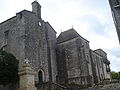
Monastery church

View of the place
_%C3%A9glise_et_abbaye.JPG)

literature
- Le Patrimoine des Communes de la Gironde. Flohic Éditions, Volume 2, Paris 2001, ISBN 2-84234-125-2 , pp. 1075-1084.