Casseuil
|
Casseuil Cassulh |
||
|---|---|---|
|
|
||
| region | Nouvelle-Aquitaine | |
| Department | Gironde | |
| Arrondissement | Langon | |
| Canton | Le Réolais and Les Bastides | |
| Community association | Réolais en Sud Gironde | |
| Coordinates | 44 ° 35 ′ N , 0 ° 7 ′ W | |
| height | 8-122 m | |
| surface | 6.34 km 2 | |
| Residents | 398 (January 1, 2017) | |
| Population density | 63 inhabitants / km 2 | |
| Post Code | 33190 | |
| INSEE code | 33102 | |
 Town Hall ( Mairie ) of Casseuil |
||
Casseuil ( Gascon : Cassulh ) is a municipality with 398 inhabitants (as of January 1 2017) in the French department of Gironde . It belongs to the canton of Le Réolais et Les Bastides in the Langon arrondissement . The inhabitants are called Casseuillais .
geography
Casseuil is about 45 kilometers southeast of Bordeaux . Here the Dropt river flows into the Garonne . Casseuil is surrounded by the neighboring communities of Sainte-Foy-la-Longue in the north and north-west, Morizès in the north and north-east, Gironde-sur-Dropt in the east, Barie in the south and Caudrot in the west.
Population development
| year | 1962 | 1968 | 1975 | 1982 | 1990 | 1999 | 2006 | 2013 |
|---|---|---|---|---|---|---|---|---|
| Residents | 356 | 315 | 347 | 361 | 395 | 367 | 359 | 392 |
| Source: Cassini and INSEE | ||||||||
Attractions
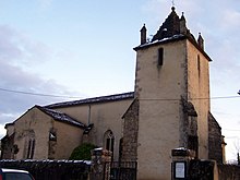
- Saint-Pierre church
- Notre-Dame-du-Paradis chapel
literature
- Le Patrimoine des Communes de la Gironde. Flohic Éditions, Volume 2, Paris 2001, ISBN 2-84234-125-2 , pp. 1206-1207.
Web links
Commons : Casseuil - collection of images, videos and audio files

