
Blasimon
|
Blasimon Blasimont |
||
|---|---|---|
.svg)
|
|
|
| region | Nouvelle-Aquitaine | |
| Department | Gironde | |
| Arrondissement | Langon | |
| Canton | Le Réolais and Les Bastides | |
| Community association | Rurales de l'Entre-Deux-Mers | |
| Coordinates | 44 ° 45 ′ N , 0 ° 4 ′ W | |
| height | 22-130 m | |
| surface | 29.76 km 2 | |
| Residents | 906 (January 1, 2017) | |
| Population density | 30 inhabitants / km 2 | |
| Post Code | 33540 | |
| INSEE code | 33057 | |
| Website | http://www.blasimon.fr/ | |
 City Hall (Mairie) of Blasimon |
||

Blasimon ( Occitan Blasimont ) is a French municipality with 906 inhabitants (as of January 1 2017) in the Gironde department in the region Nouvelle-Aquitaine . It belongs to the Arrondissement of Langon and the canton of Le Réolais et Les Bastides . The inhabitants are called Blasimonais .
geography
Blasimon is located about 45 kilometers east-southeast of Bordeaux . Blasimon is surrounded by the neighboring communities of Saint-Vincent-de-Pertignas and Mérignas in the north, Ruch in the northeast, Mauriac in the east, Cleyrac in the southeast, Sauveterre-de-Guyenne in the south, Frontenac in the southwest, Lugasson in the west and Jugazan and Rauzan in the Northwest
history
The bastide from which Blasimon emerged was founded in 1320.
Population development
| 1962 | 1968 | 1975 | 1982 | 1990 | 1999 | 2006 | 2017 |
|---|---|---|---|---|---|---|---|
| 867 | 836 | 782 | 666 | 701 | 711 | 843 | 906 |
| Sources: cassini and INSEE | |||||||
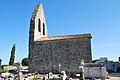
Attractions
- Dolmen of La Mouleyre
- Saint-Maurice monastery from the 12th / 13th centuries Century, since 1925 Monument historique
- Saint-Nicolas church, historic monument since 1875
- Saint Martin Church in Piis
- Labarthe mill from the 14th century
- Blasimon Castle
See also: List of Monuments historiques in Blasimon

Saint-Nicolas church
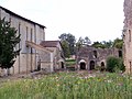
Saint-Maurice Monastery
Saint Martin Church

Blasimon Castle


literature
- Le Patrimoine des Communes de la Gironde. Flohic Éditions, Volume 2, Paris 2001, ISBN 2-84234-125-2 , pp. 1471-1473.