Pondaurat
|
Pondaurat Pontdaurat |
||
|---|---|---|

|
|
|
| region | Nouvelle-Aquitaine | |
| Department | Gironde | |
| Arrondissement | Langon | |
| Canton | Le Réolais and Les Bastides | |
| Community association | Le Réolais en Sud Gironde | |
| Coordinates | 44 ° 32 ′ N , 0 ° 5 ′ W | |
| height | 11-67 m | |
| surface | 8.74 km 2 | |
| Residents | 470 (January 1, 2017) | |
| Population density | 54 inhabitants / km 2 | |
| Post Code | 33190 | |
| INSEE code | 33331 | |
| Website | http://pondaurat.fr/ | |
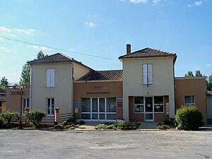
 Town Hall (Mairie) of Pondaurat |
||
Pondaurat ( Occitan Pontdaurat ) is a French municipality with 470 inhabitants (as of January 1, 2017) in the Gironde department in the region Nouvelle-Aquitaine . It belongs to the Arrondissement of Langon and the canton of Le Réolais et Les Bastides . The inhabitants are called Dorépontais .
geography
Pondaurat is about 64 kilometers south-east of Bordeaux . Pondaurat is surrounded by the neighboring municipalities of Basanne in the north and northwest, Puybarban in the north and east, Aillas in the south and southeast, Savignac in the west and southwest and Castets et Castillon in the northwest.
The A62 car route runs along the southern edge of the municipality . Pondaurat is located on Via Lemovicensis , one of the four historical " Routes of the St. James pilgrims in France ".
Population development
| 1962 | 1968 | 1975 | 1982 | 1990 | 1999 | 2006 | 2013 |
|---|---|---|---|---|---|---|---|
| 533 | 465 | 380 | 361 | 361 | 355 | 372 | 493 |
| Source: Cassini and INSEE | |||||||
Attractions
- Church of Saint-Antoine in Pondaurat from the 13th century, monument historique since 1925 , with rectory (since 1990 monument historique)
- Saint-Martin church in Montphélix
- Antonine monastery and mill from the 19th century
- House with buttresses (Monument historique)
See also: List of Monuments historiques in Pondaurat
literature
- Le Patrimoine des Communes de la Gironde. Flohic Éditions, Volume 1, Paris 2001, ISBN 2-84234-125-2 , pp. 105-108.


