
Saint-Sulpice-de-Guilleragues
|
Saint-Sulpice-de-Guilleragues Sent Sulpici de Guilheragas |
||
|---|---|---|
.svg)
|
|
|
| region | Nouvelle-Aquitaine | |
| Department | Gironde | |
| Arrondissement | Langon | |
| Canton | Le Réolais and Les Bastides | |
| Community association | Rurales de l'Entre-Deux-Mers | |
| Coordinates | 44 ° 38 ′ N , 0 ° 3 ′ E | |
| height | 18-102 m | |
| surface | 6.89 km 2 | |
| Residents | 229 (January 1, 2017) | |
| Population density | 33 inhabitants / km 2 | |
| Post Code | 33580 | |
| INSEE code | 33481 | |

Saint-Sulpice-de-Guilleragues on Gascon Sent Sulpici de Guilheragas , is a French municipality with 229 inhabitants (at January 1, 2017) in the Gironde department in the region Nouvelle-Aquitaine . It belongs to the canton of Le Réolais et Les Bastides and the Arrondissement Langon .
It is bordered by Coutures to the northwest , Le Puy to the north, Monségur to the northeast, Sainte-Gemme to the east, Fossès-et-Baleyssac to the south and Roquebrune to the west .
Population development
| year | 1962 | 1968 | 1975 | 1982 | 1990 | 1999 | 2008 | 2017 |
|---|---|---|---|---|---|---|---|---|
| Inhabit | 262 | 240 | 202 | 219 | 224 | 227 | 221 | 229 |
Attractions
- Ruins of the Château de Caze , designated as a monument historique since 2007
- Guilleragues Castle, designated as a Monument historique since 1995
- Saint-Sulpice church

Castle ruins

Guilleragues Castle
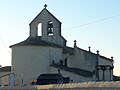
Saint-Sulpice church


literature
- Le Patrimoine des Communes de la Gironde. Flohic Éditions, Volume 2, Paris 2001, ISBN 2-84234-125-2 , pp. 1003-1004.
Web links
Commons : Saint-Sulpice-de-Guilleragues - Collection of images, videos and audio files