
Pellegrue
| Pellegrue | ||
|---|---|---|
.svg)
|
|
|
| region | Nouvelle-Aquitaine | |
| Department | Gironde | |
| Arrondissement | Langon | |
| Canton | Le Réolais and Les Bastides | |
| Community association | Pays Foyen | |
| Coordinates | 44 ° 45 ′ N , 0 ° 5 ′ E | |
| height | 33-132 m | |
| surface | 38.18 km 2 | |
| Residents | 1,099 (January 1, 2017) | |
| Population density | 29 inhabitants / km 2 | |
| Post Code | 33790 | |
| INSEE code | 33316 | |
| Website | http://www.pellegrue.com/ | |

Pellegrue is a French commune with 1,099 inhabitants (at January 1, 2017) in the Gironde department in the region Nouvelle-Aquitaine . It belonged from February 17, 1800 to September 10, 1926 to the Arrondissement de La Réole , whose district was then struck to the Arrondissement Langon . Pellegrue belongs to the canton of Le Réolais et Les Bastides .
The village emerged from a bastide ; it is located on Route nationale 672 between Sainte-Foy-la-Grande and Sauveterre-de-Guyenne . Pellegrue is located on Via Lemovicensis , one of the four historical " Routes of the St. James pilgrims in France ".
Population development
| year | 1962 | 1968 | 1975 | 1982 | 1990 | 1999 | 2009 | 2017 |
|---|---|---|---|---|---|---|---|---|
| Residents | 1248 | 1343 | 1144 | 1065 | 1046 | 979 | 1005 | 1099 |
Attractions
- The Saint-André church was built in the 13th century with a plan in the shape of a Latin cross. The west facade is Romanesque , the tower was built in the 19th century in neo-Byzantine style . It has been a monument historique since 1925 .
- The castle, Château du Puch de Gensac , was built in the 13th century and expanded in the 16th and 17th centuries. It has been a monument historique since 1994 .
- Market hall
See also: List of the Monuments historiques in Pellegrue

Church Saint-André

Château du Puch de Gensac
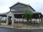
Market hall


,_les_Halles.JPG)
literature
- Le Patrimoine des Communes de la Gironde. Flohic Éditions, Volume 2, Paris 2001, ISBN 2-84234-125-2 , pp. 1063-1070.
Web links
Commons : Pellegrue - collection of images, videos and audio files