
Verdelais
| Verdelais | ||
|---|---|---|
|
||
| region | Nouvelle-Aquitaine | |
| Department | Gironde | |
| Arrondissement | Langon | |
| Canton | L'Entre-deux-Mers | |
| Community association | South Gironde | |
| Coordinates | 44 ° 35 ′ N , 0 ° 15 ′ W | |
| height | 2–103 m | |
| surface | 4.75 km 2 | |
| Residents | 1,031 (January 1, 2017) | |
| Population density | 217 inhabitants / km 2 | |
| Post Code | 33490 | |
| INSEE code | 33543 | |
| Website | http://www.verdelais.fr/ | |
 Verdelais town hall |
||

Verdelais ( Gascon identical) is a commune with 1,031 inhabitants (as of January 1 2017) in the Gironde department in the region Nouvelle-Aquitaine (before 2016 Aquitaine ). It belongs to the arrondissement of Langon and the canton of L'Entre-deux-Mers (until 2015 Saint-Macaire ). The inhabitants are called Verdelaisiens .
geography
Verdelais is located in the southwest of France . The Garonne borders the municipality in the southwest . To the north and west of the municipality is Sainte-Croix-du-Mont , to the north and northeast of Semens , to the northeast of Saint-André-du-Bois , to the east and south of Saint-Maixant and to the south and southwest of Toulenne .
Population development
| year | 1962 | 1968 | 1975 | 1982 | 1990 | 1999 | 2008 | 2017 |
| Residents | 846 | 831 | 923 | 880 | 869 | 869 | 826 | 1031 |
| Sources: Cassini and INSEE | ||||||||
Attractions
- Notre-Dame Basilica, built as a chapel in the 12th century, rebuilt in the mid-19th century, monument historique since 2010
- Saint-Maurice church in Aubiac from the 12th century, historic monument since 1973
- Celestine Convention
- Cussol Mill
- Villa Saint-Michel
See also: List of Monuments historiques in Verdelais

Notre-Dame basilica

Saint-Maurice Church
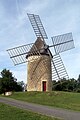
Mill Cussol


Personalities
- Henri de Toulouse-Lautrec (1864–1901), painter and graphic artist
literature
- Le Patrimoine des Communes de la Gironde. Flohic Éditions, Volume 2, Paris 2001, ISBN 2-84234-125-2 , pp. 1337-1341.