
Saint-Michel-de-Lapujade
|
Saint-Michel-de-Lapujade Sent Miquèu de la Pojada |
||
|---|---|---|
|
||
| region | Nouvelle-Aquitaine | |
| Department | Gironde | |
| Arrondissement | Langon | |
| Canton | Le Réolais and Les Bastides | |
| Community association | Réolais en Sud Gironde | |
| Coordinates | 44 ° 35 ' N , 0 ° 4' E | |
| height | 24-122 m | |
| surface | 7.47 km 2 | |
| Residents | 233 (January 1, 2017) | |
| Population density | 31 inhabitants / km 2 | |
| Post Code | 33190 | |
| INSEE code | 33453 | |
| Website | http://stmicheldelapujade.free.fr/ | |
 Town hall (Mairie) of Saint-Michel-de-Lapujade |
||

Saint-Michel-de-Lapujade ( Occitan Sent Miquèu de la Pojada ) is a French municipality with 233 inhabitants (as of January 1 2017) in the Gironde department in the region Nouvelle-Aquitaine . It belongs to the Arrondissement of Langon and the canton of Le Réolais et Les Bastides . The inhabitants are called Lapujadais .
geography
Saint-Michel-de-Lapujade is about 75 kilometers southeast of Bordeaux . Saint-Michel-de-Lapujade is surrounded by the neighboring communities of Fossès-et-Baleyssac in the north and north-west, Sainte-Gemme in the north, Saint-Vivien-de-Monségur in the north and north-east, Castelnau-sur-Gupie in the east and south-east, Saint-Martin-Petit and Lamothe-Landerron in the south and Mongauzy in the west and south-west.
Population development
| 1962 | 1968 | 1975 | 1982 | 1990 | 1999 | 2006 | 2017 |
|---|---|---|---|---|---|---|---|
| 222 | 217 | 209 | 221 | 222 | 221 | 204 | 233 |
| Sources: Cassini and INSEE | |||||||
Attractions
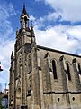
- Saint-Michel church from the 12th century, historic monument since 1925
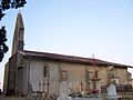
- Notre-Dame-de-Lorette church from the 13th century
- Watermill
Notre-Dame-de-Lorette church
Saint-Michel church


literature
- Le Patrimoine des Communes de la Gironde. Flohic Éditions, Volume 2, Paris 2001, ISBN 2-84234-125-2 , pp. 1237-1238.