
Cours-les-Bains
|
Cours-les-Bains Corts |
||
|---|---|---|
|
||
| region | Nouvelle-Aquitaine | |
| Department | Gironde | |
| Arrondissement | Langon | |
| Canton | Le Sud-Gironde | |
| Community association | Bazadais | |
| Coordinates | 44 ° 23 ′ N , 0 ° 1 ′ W | |
| height | 85-167 m | |
| surface | 10.43 km 2 | |
| Residents | 222 (January 1, 2017) | |
| Population density | 21 inhabitants / km 2 | |
| Post Code | 33690 | |
| INSEE code | 33137 | |
| Website | http://courslesbains.fr/z/index.php | |
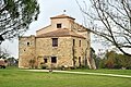
 Town hall (Mairie) of Cours-les-Bains |
||

Cours-les-Bains ( Gascon Corts ) is a French municipality with 222 inhabitants (at January 1, 2017) in the Gironde department in the region Nouvelle-Aquitaine (before 2016 Aquitaine ). It belongs to the Arrondissement Langon and the canton Le Sud-Gironde (until 2015 Grignols ). The inhabitants are called Bennicoursins .
geography
Cours-les-Bains is 75 kilometers south-east of Bordeaux and about 35 kilometers south-east of Langon . Cours-les-Bains is surrounded by the neighboring communities of Grignols in the north and west, Romestaing in the north-east, Ruffiac in the east and south-east, Antagnac in the south, Saint-Martin-Curton in the south and south-west and Sillas in the west and south-west.
Population development
| year | 1962 | 1968 | 1975 | 1982 | 1990 | 1999 | 2006 | 2013 |
|---|---|---|---|---|---|---|---|---|
| Residents | 288 | 223 | 201 | 175 | 138 | 157 | 199 | 190 |
| Source: Cassini and INSEE | ||||||||
Attractions
- Notre-Dame church from the 19th century (see also: List of Monuments historiques in Cours-les-Bains )
- Coming of the Knights Templar
- Thermal springs

Notre-Dame church
Remnants of the coming


literature
- Le Patrimoine des Communes de la Gironde. Flohic Éditions, Volume 1, Paris 2001, ISBN 2-84234-125-2 , pp. 740-742.
Web links
Commons : Cours-les-Bains - Collection of images, videos and audio files