
Romestaing
| Romestaing | ||
|---|---|---|
|
||
| region | Nouvelle-Aquitaine | |
| Department | Lot-et-Garonne | |
| Arrondissement | Marmande | |
| Canton | Les Forêts de Gascogne | |
| Community association | Communes des Coteaux et Landes de Gascogne | |
| Coordinates | 44 ° 25 ′ N , 0 ° 0 ′ E | |
| height | 56-167 m | |
| surface | 15.46 km 2 | |
| Residents | 166 (January 1, 2017) | |
| Population density | 11 inhabitants / km 2 | |
| Post Code | 47250 | |
| INSEE code | 47224 | |
| Website | www.romestaing.fr | |
 Mayor's office ( Mairie ) of Romestaing |
||

Romestaing is a French municipality with 166 inhabitants (at January 1, 2017) in the department of Lot-et-Garonne in the region Nouvelle-Aquitaine (before 2016: Aquitaine ). The municipality belongs to the arrondissement of Marmande and the canton of Les Forêts de Gascogne (until 2015: canton of Bouglon ).
The name in the Gascognic language is Romestanh . It has its origin in the Latin name of the Romana Statio , an important intersection of two Roman roads . A second theory suggests that the name is a derivative of the patronymic Hromstang .
The inhabitants are called Romestaingais and Romestaingaises .
geography
Romestaing is located approx. 15 km southwest of Marmande in the Bazadais region of the historic Gascogne province on the western border with the neighboring Gironde department .
Romestaing is surrounded by the six neighboring communities:
| Cocumont | ||
|
Grignols (Gironde) |
.svg)
|
Guérin |
|
Cours-les-Bains (Gironde) |
Ruffiac | Argenton |
Romestaing lies in the catchment area of the Garonne River .
The Sérac, a tributary of the Avance , crosses the territory of the commune along with its tributaries,
- the Ruisseau du Ray,
- the Ruisseau d'Esquerdes,
- the Ruisseau de Pédeloup,
- the Ruisseau de Sangos,
- the Ruisseau de Saignou and
- the Ruisseau de Gouts.
The Ruisseau du Trône, a tributary of the Lisos , forms the natural border with the southern neighboring municipality of Ruffiac.
history
In the 19th century, the location of a moth from the High Middle Ages was discovered in today's hamlet of Saboureau on the north-eastern edge of the municipality. Objects made of iron, pottery shards and a human skeleton in a fetal position came to light.
In the second half of the 12th century founded the Templars during the reign of the English King Henry the Younger in Romestaing a Commandery that the district of Cours belonged. Only a fortified church from the 11th century remains of it. Philip the Fair was jealous of the power of the knightly order and pushed for its removal at the beginning of the 14th century. Pope Clement V ordered the dissolution of the Knights Templar on April 13, 1312. It was replaced in the course of the 16th century by the competing order of the Maltese , who in turn founded numerous commanderies in what is now the Lot-et-Garonne department until the French Revolution . In Romestaing they owned especially arable land. For this reason, boundary stones bearing the Maltese cross can still be seen in the area around Romestaing .
When the Second World War broke out , the population of Alsace was evacuated. Residents of the Obersaasheim community were admitted to Guérin and Romestaing.
Population development
After records began, the population rose to a peak of around 495 by the middle of the 19th century. In the following period, the size of the community fell to around 215 inhabitants during short recovery phases by the 1990s, before a phase of moderate growth began.
| year | 1962 | 1968 | 1975 | 1982 | 1990 | 1999 | 2006 | 2011 | 2017 |
|---|---|---|---|---|---|---|---|---|---|
| Residents | 272 | 247 | 219 | 227 | 217 | 234 | 235 | 250 | 166 |


Town twinning
Romestaing maintains a town partnership with Obersaasheim in the Haut-Rhin department in Alsace in the Grand Est region .
Attractions
Parish Church of Saint-Christophe
It was built in the 12th century and belonged to the Commandery of the Knights Templar until the 14th century. The choir and the space in front of it have a stone vault in a manner typical for the area , while the vault of the nave is made of brick. The nave has a length of four bays or 18 meters and a width of six meters. The ceiling of the vestibule, which is located below the square bell tower , is supported by columns with ornate capitals , typical examples of Romanesque art. They show Noah naked beneath a bunch of grapes, a person covered by a cloak, another person laughing, birds, monks, lions fighting with two naked men. A narrow tower leaning on the north side hides a spiral staircase that leads up to the bell tower. The entrance to today's sacristy initially led into the commandery, of which nothing remained. The church has been inscribed as a Monument historique since March 30, 1965 . The main altar of the church from the early 19th century is inscribed as a monument historique of movable property. It is a work that is characterized by great objectivity, created under the influence of the classical art movement. Its lines are geometric, its composition is symmetrical and its decor is simple. The Maltese cross appears as a recurring motif and is reminiscent of the Commandery of the Templars.
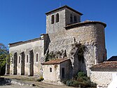
Parish Church of Saint-Christophe
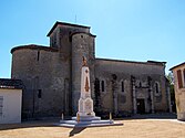
North side with war memorial
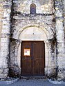
Entrance portal


Economy and Infrastructure
Agriculture, cattle and sheep breeding and foie gras as a specialty should be emphasized . There are numerous second homes. The village is particularly popular because of the hiking and riding trails through the forest. Art exhibitions are organized in summer.
Romestaing is in the AOC des Côtes du Marmandais ( blanc, rosé, rouge ) zone .

Total = 21
traffic
Romestaing can be reached via Routes départementales 3 (Gironde: 65haben), 147 and 252.
Web links
Individual evidence
- ↑ Gasconha.com ( fr ) Gasconha.com. Retrieved April 22, 2019.
- ↑ a b c Romestaing ( fr ) Conseil régional d'Aquitaine. Archived from the original on September 9, 2016. Retrieved April 22, 2019.
- ↑ a b Romestaing ( fr ) Municipal Romestaing. Retrieved April 22, 2019.
- ↑ Lot-et-Garonne ( fr ) habitants.fr. Retrieved April 22, 2019.
- ↑ Ma commune: Romestaing ( fr ) Système d'Information sur l'Eau du Bassin Adour Garonne. Retrieved April 22, 2019.
- ↑ a b Haut-Rhin & Lot-et-Garonne - 1939-2009 ( fr , PDF) Tourist associations and departmental councils of the Haut-Rhin and Lot-et-Garonne departments. Retrieved April 22, 2019.
- ↑ Notice Communale Romestaing ( fr ) EHESS . Retrieved April 22, 2019.
- ↑ Populations légales 2016 Commune de Romestaing (47224) ( fr ) INSEE . Retrieved April 22, 2019.
- ^ Eglise Saint-Christophe ( fr ) French Ministry of Culture . September 22, 2015. Accessed April 22, 2019.
- ^ Église Saint-Christophe ( fr ) Conseil régional d'Aquitaine. Archived from the original on March 3, 2016. Retrieved April 22, 2019.
- ↑ Maître-autel ( fr ) French Ministry of Culture . December 30, 2015. Accessed April 22, 2019.
- ↑ Autel de l'église Saint-Christophe ( fr ) Conseil régional d'Aquitaine. Archived from the original on March 3, 2016. Retrieved April 22, 2019.
- ↑ Institut national de l'origine et de la qualité: Rechercher un produit ( fr ) Institut national de l'origine et de la qualité . Retrieved April 22, 2019.
- ↑ Caractéristiques des établissements en 2015 Commune de Romestaing (47224) ( fr ) INSEE . Retrieved April 22, 2019.