
Laughter chapel (Lot-et-Garonne)
| Laughing Chapel | ||
|---|---|---|
|
||
| region | Nouvelle-Aquitaine | |
| Department | Lot-et-Garonne | |
| Arrondissement | Marmande | |
| Canton | Les Coteaux de Guyenne | |
| Community association | Communes du Pays de Lauzun | |
| Coordinates | 44 ° 35 ' N , 0 ° 16' E | |
| height | 52-132 m | |
| surface | 4.53 km 2 | |
| Residents | 84 (January 1, 2017) | |
| Population density | 19 inhabitants / km 2 | |
| Post Code | 47350 | |
| INSEE code | 47126 | |
 Mayor's office of Lachapelle |
||

LaChapelle is a French municipality with 84 inhabitants (at January 1, 2017) in the department of Lot-et-Garonne in the region Nouvelle-Aquitaine (before 2016: Aquitaine ). The municipality belongs to the arrondissement of Marmande and the canton of Les Coteaux de Guyenne (until 2015: canton of Seyches ).
The name of the parish is derived from the name of the former parish Sancti Petri de Capella .
The inhabitants are called chapellois and chapelloises .
geography
Lachapelle is located about 12 kilometers northeast of Marmande in the historic province of Agenais on the northwestern edge of the department.
Lachapelle is surrounded by the five neighboring communities:
| Cambes | ||
| Saint-Avit |
.svg)
|
Peyriere |
| Escassefort | Seyches |
Lachapelle lies in the catchment area of the Garonne River .
The Gupie , one of its tributaries, forms a natural border with the neighboring municipality of Saint-Avit to the south. Its tributaries, the Ruisseau de Pinasseau and the Ruisseau de Boutié with its tributary Ruisseau de Combeau, also irrigate the territory of the municipality.
history
In 1984 archaeological excavations were carried out in the hamlet of Saint-Martin, south of the center of the municipality. A cemetery was discovered that was in use from the sixth to the early 18th centuries. Thirty-nine tombs have been unearthed, eight of which are dated between the sixth and seventh centuries. They contained extensive accessories, including numerous items of clothing. All graves were oriented to the east and arranged in parallel rows.
In the Middle Ages , the parish of Lachapelle was a branch of Seyches.
Population development
After records began, the population rose to a peak of around 355 by the middle of the 19th century. In the period that followed, the size of the community declined with short recovery phases, a trend that continues to this day.
| year | 1962 | 1968 | 1975 | 1982 | 1990 | 1999 | 2006 | 2011 | 2017 |
|---|---|---|---|---|---|---|---|---|---|
| Residents | 132 | 108 | 104 | 91 | 89 | 92 | 97 | 86 | 84 |

Parish Church of Saint-Roch
The original church suffered numerous lootings. Today's church is a new building from the 18th century. The bell tower was erected in 1873. Its specialty is its polygonal spire.

Saint-Roch church
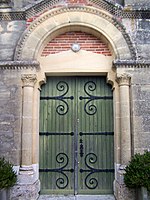
One of the two entrances to the church


Economy and Infrastructure
Lachapelle is in the AOC zone of the wines of the Côtes du Marmandais region .

total = 11
traffic
Lachapelle can be reached via Route départementale 228 and via secondary roads that branch off from Routes départementales 132 and 297.
Web links
Individual evidence
- ↑ a b c d Lachapelle ( fr ) Conseil régional d'Aquitaine. Archived from the original on September 9, 2016. Retrieved March 13, 2019.
- ↑ Lot-et-Garonne ( fr ) habitants.fr. Retrieved March 13, 2019.
- ↑ Ma commune: Lachapelle ( fr ) Système d'Information sur l'Eau du Bassin Adour Garonne. Retrieved March 13, 2019.
- ↑ Notice Communale Lachapelle ( fr ) EHESS . Retrieved March 13, 2019.
- ↑ Populations légales 2016 Commune de Lachapelle (47126) ( fr ) INSEE . Retrieved March 13, 2019.
- ↑ Institut national de l'origine et de la qualité: Rechercher un produit ( fr ) Institut national de l'origine et de la qualité . Retrieved March 13, 2019.
- ↑ Caractéristiques des établissements en 2015 Commune de Lachapelle (47126) ( fr ) INSEE . Retrieved March 13, 2019.