
Grézet-Cavagnan
|
Grézet-Cavagnan Lo Gresèth e Cavanhan |
||
|---|---|---|
|
||
| region | Nouvelle-Aquitaine | |
| Department | Lot-et-Garonne | |
| Arrondissement | Marmande | |
| Canton | Les Forêts de Gascogne | |
| Community association | Coteaux et Landes de Gascogne | |
| Coordinates | 44 ° 23 ' N , 0 ° 8' E | |
| height | 39–157 m | |
| surface | 12.55 km 2 | |
| Residents | 385 (January 1, 2017) | |
| Population density | 31 inhabitants / km 2 | |
| Post Code | 47250 | |
| INSEE code | 47114 | |
 Town hall (Mairie) of Grézet-Cavagnan |
||

Grezet-Cavagnan ( Occitan : Lo Gresèth e Cavanhan ) is a French municipality with 385 inhabitants (as of January 1 2017) in the department of Lot-et-Garonne in the region Nouvelle-Aquitaine (before 2016: Aquitaine ). The municipality belongs to the arrondissement of Marmande and the canton of Les Forêts de Gascogne (until 2015: canton of Bouglon ). The inhabitants are called Grézetois .
geography
Grézet-Cavagnan is located about 13 kilometers south-southwest of Marmande . Neighboring communities of Grézet-Cavagnan are Bouglon in the north and north-west, Sainte-Marthe in the north and north-east, Sainte-Gemme-Martaillac in the east, Labastside-Castel-Amouroux in the south, Poussignac in the south-west and Argenton in the west.
Population development
| year | 1962 | 1968 | 1975 | 1982 | 1990 | 1999 | 2006 | 2013 |
| Residents | 390 | 344 | 314 | 294 | 296 | 256 | 329 | 363 |
| Source: Cassini and INSEE | ||||||||
Attractions
- Saint-Caprais church in Grézet from the 15th century
- Saint Hilaire church in Cavagnan from the 12th century
- Malvirade Castle, originally from the 12th century, today's building partly from the 17th century, Monument historique

Saint-Caprais church

Saint-Hilaire church
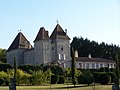
Malvirade Castle


