
Saint-Pierre-sur-Dropt
|
Saint-Pierre-sur-Dropt Sent Pèir de Dròt |
||
|---|---|---|
|
||
| region | Nouvelle-Aquitaine | |
| Department | Lot-et-Garonne | |
| Arrondissement | Marmande | |
| Canton | Les Coteaux de Guyenne | |
| Community association | Pays de Duras | |
| Coordinates | 44 ° 39 ′ N , 0 ° 12 ′ E | |
| height | 28-70 m | |
| surface | 8.18 km 2 | |
| Residents | 338 (January 1, 2017) | |
| Population density | 41 inhabitants / km 2 | |
| Post Code | 47120 | |
| INSEE code | 47271 | |
 Mairie of Saint-Pierre-sur-Dropt |
||

Saint-Pierre-sur-Dropt ( Occitan Sent Peir de Drot ) is a French municipality with 338 inhabitants (at January 1, 2017) in the department of Lot-et-Garonne in the region Nouvelle-Aquitaine (before 2016 Aquitaine ). It belongs to the Arrondissement Marmande and the canton Les Coteaux de Guyenne (until 2015 Seyches ). The inhabitants are called Saint-Pierrois .
geography
Saint-Pierre-sur-Dropt is about twenty kilometers north of Marmande am Dropt . Neighboring municipalities of Saint-Pierre-sur-Dropt are Duras in the north, Auriac-sur-Dropt in the east, Lévignac-de-Guyenne in the south and Taillecavat in the west.
Population development
| year | 1962 | 1968 | 1975 | 1982 | 1990 | 1999 | 2006 | 2011 | 2016 |
| Residents | 260 | 282 | 295 | 263 | 244 | 226 | 254 | 285 | 325 |
| Source: Cassini and INSEE | |||||||||
Attractions
- Saint-Pierre church
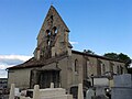
Saint-Pierre church

Web links
Commons : Saint-Pierre-sur-Dropt - Collection of images, videos and audio files