
Grateloup-Saint-Gayrand
| Grateloup-Saint-Gayrand | ||
|---|---|---|
|
||
| region | Nouvelle-Aquitaine | |
| Department | Lot-et-Garonne | |
| Arrondissement | Marmande | |
| Canton | Tonneins | |
| Community association | Val de Garonne agglomeration | |
| Coordinates | 44 ° 25 ' N , 0 ° 23' E | |
| height | 42-172 m | |
| surface | 20.67 km 2 | |
| Residents | 428 (January 1, 2017) | |
| Population density | 21 inhabitants / km 2 | |
| Post Code | 47400 | |
| INSEE code | 47112 | |
| Website | vg-agglo.localeo.fr/grateloup | |
 Mayor's office and school |
||

Grateloup-Saint-Gayrand is a French municipality with 428 inhabitants (at January 1, 2017) in the department of Lot-et-Garonne in the region Nouvelle-Aquitaine (before 2016: Aquitaine ). The municipality belongs to the arrondissement of Marmande and the canton of Tonneins (until 2015: canton of Castelmoron-sur-Lot ).
The first part of the name is derived from the Latin expression locus gratus ( German pleasant place ). The second part of the name goes back to a martyr of the third or fourth century.
The inhabitants are called Grateloupais and Grateloupaises .
geography
Grateloup-Saint-Gayrand is located approx. 20 km southeast of Marmande and approx. 30 km northwest of Agen in the historic province of Agenais .
Grateloup-Saint-Gayrand is surrounded by the six neighboring municipalities:
| Varès | Verteuil-d'Agenais | Brugnac |
.svg)
|
Laparade | |
| Tonneins | Clairac |
Grateloup-Saint-Gayrand lies in the catchment area of the Garonne River .
One of its tributaries, the Tolzac , crosses the territory of the municipality together with its tributaries,
- the Le Ravin de Saury,
- the Ruisseau de la Forêt, which rises in Grateloup-Saint-Gayrand, and
- the Torgue with its tributary,
- the rose.
history
The construction of churches in the 11th or 12th centuries gave impetus to the development of the parishes of Grateloup and Saint-Gayrand. In the case of Grateloup, it was added to a moth . Excavations at this point revealed that it was already settled in Gallo-Roman times .
As a result, the village of Saint-Gayrand developed widely, while the village of Grateloup expanded in a circular arc at the foot of the Motte and away from the church. in a commemorative publication from 1259 it was referred to as a fortified place ( castrum ). A treaty on the division of feudal rights at the end of the 13th or beginning of the 14th century suggests that the establishment of a bastide was up for debate.
The Huguenot Wars shaped the history of the two villages. Grateloup was a center of Protestantism in the 16th and 17th centuries. Therefore the two parish churches were destroyed. A Protestant church was built towards the end of the 16th century, and there was a Huguenot school in the 17th century .
After the French Revolution , the villages became two communities, which merged on August 1, 1972 as Communes associées . On August 1, 1999, it became a simple merger, and on April 14, 2002, Grateloup was renamed Grateloup-Saint-Gayrand.
Population development
After records began, the population rose to a peak of around 650 by the first half of the 19th century. In the following period, the size of the community fell to around 305 inhabitants during short recovery phases by the 1940s, before a phase of moderate growth began . Supported by the merger with Saint-Gayrand, a level of around 430 inhabitants was reached from 1975.
| year | 1962 | 1968 | 1975 | 1982 | 1990 | 1999 | 2006 | 2011 | 2017 |
|---|---|---|---|---|---|---|---|---|---|
| Residents | 326 | 338 | 458 | 451 | 452 | 416 | 419 | 447 | 428 |

Attractions
- Parish church of Saint-Caprais in Grateloup, rebuilt in the 16th century after being destroyed
- Parish Church of Saint-Gayrand Saint-Gayrand, in the 16th century after the destruction at the end of the Hundred Years War rebuilt
- Ruins of the former parish church of Saint-Gayrand in Saint-Gayrand from the 12th century, inscribed as a monument historique
- Lagarde Castle from the 17th century, inscribed as a monument historique
- Mayor's office and school from the 19th century
- Protestant church, rebuilt in the 19th century after being destroyed at the end of the 16th century
- Watermill above the Tolzac, called Rocquebert Mill, new building from the 18th century
- 18th century watermill above the Torgue

Parish Church of Saint-Caprais

Former parish church of Saint-Gayrand
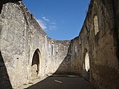
Nave overlooking the choir


Economy and Infrastructure
Agriculture with arable and livestock farming is the municipality's most important economic factor.

total = 43
traffic
Grateloup-Saint-Gayrand can be reached via Routes départementales 101, 120, 126, 263 and 301.
Web links
Individual evidence
- ↑ a b c Grateloup-Saint-Gayrand ( fr ) Conseil régional d'Aquitaine. Archived from the original on September 9, 2016. Retrieved February 11, 2019.
- ↑ Lot-et-Garonne ( fr ) habitants.fr. Retrieved February 11, 2019.
- ↑ Ma commune: Grateloup-Saint-Gayrand ( fr ) Système d'Information sur l'Eau du Bassin Adour Garonne. Retrieved February 11, 2019.
- ↑ Commune de Grateloup-Saint-Gayrand (47112) ( fr ) INSEE . Retrieved February 11, 2019.
- ^ Notice Communale Grateloup-Saint-Gayrand ( fr ) EHESS . Retrieved February 11, 2019.
- ↑ Populations légales 2016 Commune de Grateloup-Saint-Gayrand (47112) ( fr ) INSEE . Retrieved February 11, 2019.
- ↑ Caractéristiques des établissements en 2015 Commune de Grateloup-Saint-Gayrand (47112) ( fr ) INSEE . Retrieved February 11, 2019.