Miramont-de-Guyenne
|
Miramont-de-Guyenne Miramont de Guiana |
||
|---|---|---|

|
|
|
| region | Nouvelle-Aquitaine | |
| Department | Lot-et-Garonne | |
| Arrondissement | Marmande | |
| Canton | Le Val du Dropt (main town) | |
| Community association | Pays de Lauzun | |
| Coordinates | 44 ° 36 ' N , 0 ° 22' E | |
| height | 42-120 m | |
| surface | 16.66 km 2 | |
| Residents | 3,154 (January 1, 2017) | |
| Population density | 189 inhabitants / km 2 | |
| Post Code | 47800 | |
| INSEE code | 47168 | |
| Website | www.ville-miramontdeguyenne.fr/ | |
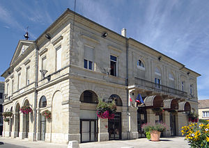
 Miramont-de-Guyenne town hall |
||
Miramont-de-Guyenne is a French municipality with 3154 inhabitants (as of January 1 2017) in the department of Lot-et-Garonne in the region Nouvelle-Aquitaine . Miramont-de-Guyenne is part of the Marmande arrondissement and the canton of Le Val du Dropt .
geography
Miramont-de-Guyenne lies on the Dourdenne . Miramont-de-Guyenne is surrounded by the neighboring communities of Roumagne in the north and north-west, Saint-Pardoux-Isaac in the north and north-east, Lavergne in the east, Armillac in the south-east, Montignac-Toupinerie in the south, Seyches and Peyrière in the south-west and Puysserampion in the west.
The former Routes nationales 133 (today D933), 667 and Route nationale 668 run through the municipality .
history
In 1211 a Grammontens priory was established here. The Bastide Miramont de Lauzun was built between 1278 and 1286. The Knights Templar had properties here.
Population development
| year | 1962 | 1968 | 1975 | 1982 | 1990 | 1999 | 2006 | 2011 |
| Residents | 3,038 | 3,744 | 3,964 | 3,692 | 3,450 | 3,360 | 3,241 | 3,326 |
Attractions
- Sainte-Marie church from 1860
- Béffery Church from the 13th century
- Bouilhaguet Castle
Personalities
- Jacques-Philippe Delmas de Grammont (1796–1862), General
- Guy Casaril (1933-1996), director

