
Guérin (Lot-et-Garonne)
| Guérin | ||
|---|---|---|
|
||
| region | Nouvelle-Aquitaine | |
| Department | Lot-et-Garonne | |
| Arrondissement | Marmande | |
| Canton | Les Forêts de Gascogne | |
| Community association | Communes des Coteaux et Landes de Gascogne | |
| Coordinates | 44 ° 25 ′ N , 0 ° 4 ′ E | |
| height | 57-146 m | |
| surface | 10.43 km 2 | |
| Residents | 249 (January 1, 2017) | |
| Population density | 24 inhabitants / km 2 | |
| Post Code | 47250 | |
| INSEE code | 47115 | |
 Mayor's Office of Guérin |
||

Guerin is a French municipality with 249 inhabitants (at January 1, 2017) in the department of Lot-et-Garonne in the region Nouvelle-Aquitaine (before 2016: Aquitaine ). The municipality belongs to the arrondissement of Marmande and the canton of Les Forêts de Gascogne (until 2015: canton of Bouglon ).
The name of the community has its origin in the Germanic name "Warin".
The inhabitants are called Guérinais and Guérinaises .
geography
Guérin is located about 13 km southwest of Marmande in the Bazadais region of the historic Gascogne province on the western edge of the department.
Guérin is surrounded by the six neighboring communities:
| Cocumont | Montpouillan | Samazan |
| Romestaing |
.svg)
|
Bouglon |
| Argenton |
Guérin is located in the catchment area of the Garonne River .
Tributaries of the Avance cross the territory of the municipality, the Ruisseau d'Argenton and the Ruisseau des Poulets.
Tributaries of the Sérac arise in the municipality,
- the Ruisseau d'Esquerdes and
- the Ruisseau de Gouts, also called Ruisseau de Bitaillet in the upper reaches, and its tributary,
- the Ruisseau de Fontet.
The Ruisseau de Samadet, a tributary of the Avançot, also irrigates the municipality.
history
Guérin is in a zone of numerous archaeological finds. Remains of a building from antiquity , coins and pottery shards have come to light during excavations.
In the Ancien Régime , the parish was part of the Archpriesthood of Sadirac in the Bazas diocese . During the French Revolution , the constitutional clergy decided that Guérin would retain the status of parish office. Nevertheless, the rectory and its garden were sold as a national property.
When the Second World War broke out , the population of Alsace was evacuated. Residents of the Obersaasheim community were admitted to Guérin and Romestaing.
Population development
After records began, the population rose to a peak of around 495 by the middle of the 19th century. In the following period, the size of the community fell to around 215 inhabitants during short recovery phases by the 1990s, before a phase of moderate growth began.
| year | 1962 | 1968 | 1975 | 1982 | 1990 | 1999 | 2006 | 2011 | 2017 |
|---|---|---|---|---|---|---|---|---|---|
| Residents | 272 | 247 | 219 | 227 | 217 | 234 | 235 | 250 | 249 |

Town twinning
Guerin maintains a city partnership with Obersaasheim in the department of Haut-Rhin in the Alsace region in the Grand Est .
Attractions
- Church of Our Lady in the hamlet Fontet, from the 13th century, when historique monument inscribed
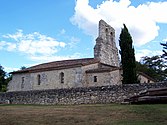
- 19th century parish church of Saint-Côme-et-Saint-Damien
- Church Saint-Christophe in the hamlet Esquerdes from the 12th century

Notre-Dame church

Parish Church of Saint-Côme-et-Saint-Damien
Saint-Christophe Church


Economy and Infrastructure
Agriculture with arable farming, viticulture and horticulture and forestry are the most important economic factors in the municipality.
Guérin is in the AOC des Côtes du Marmandais ( blanc, rosé, rouge ) zone .

Total = 31
education
The municipality has a public pre-school with 18 students in the 2018/2019 school year.
traffic
Guérin can be reached via Routes départementales 147 and 289.
Web links
Individual evidence
- ↑ a b c Guérin ( fr ) Conseil régional d'Aquitaine. Archived from the original on September 9, 2016. Retrieved February 11, 2019.
- ↑ Lot-et-Garonne ( fr ) habitants.fr. Retrieved February 11, 2019.
- ↑ Ma commune: Guérin ( fr ) Système d'Information sur l'Eau du Bassin Adour Garonne. Retrieved February 11, 2019.
- ↑ a b Haut-Rhin & Lot-et-Garonne - 1939-2009 ( fr , PDF) Tourism associations and departmental councils of the Haut-Rin and Lot-et-Garonne departments. Retrieved April 12, 2019.
- ↑ Notice Communale Guérin ( fr ) EHESS . Retrieved February 11, 2019.
- ↑ Populations légales 2016 Commune de Guérin (47115) ( fr ) INSEE . Retrieved February 11, 2019.
- ↑ Institut national de l'origine et de la qualité: Rechercher un produit ( fr ) Institut national de l'origine et de la qualité . Retrieved February 11, 2019.
- ↑ Caractéristiques des établissements en 2015 Commune de Guérin (47115) ( fr ) INSEE . Retrieved February 11, 2019.
- ^ École maternelle ( fr ) National Ministry of Education. Retrieved February 11, 2019.