
Loubès-Bernac
| Loubès-Bernac | ||
|---|---|---|
|
||
| region | Nouvelle-Aquitaine | |
| Department | Lot-et-Garonne | |
| Arrondissement | Marmande | |
| Canton | Les Coteaux de Guyenne | |
| Community association | Pays de Duras | |
| Coordinates | 44 ° 44 ′ N , 0 ° 18 ′ E | |
| height | 74-187 m | |
| surface | 19.31 km 2 | |
| Residents | 415 (January 1, 2017) | |
| Population density | 21 inhabitants / km 2 | |
| Post Code | 47120 | |
| INSEE code | 47151 | |
 Village and its historic lavoir |
||

Loubès-Bernac is a French municipality with 415 inhabitants (at January 1, 2017) in the department of Lot-et-Garonne in the region Nouvelle-Aquitaine . It belongs to the arrondissement of Marmande and the canton of Les Coteaux de Guyenne .
Neighboring municipalities of Loubès-Bernac are Margueron in the north, Monestier in the northeast, Thénac in the east, Saint-Julien-Innocence-Eulalie with Sainte-Eulalie-d'Eymet in the southeast, Soumensac in the south, Saint-Jean-de-Duras in the southwest, Saint-Astier to the west and Villeneuve-de-Duras to the northwest.
Population development
| year | 1962 | 1968 | 1975 | 1982 | 1990 | 1999 | 2008 |
| Residents | 562 | 505 | 395 | 358 | 319 | 309 | 402 |
politics
Mayor Joël Kleiber has been since 2008.

town hall

post Office

school


Attractions
- Château Théobon from the 14th century (rebuilt in the 17th century), 0.5 km northeast of the village

Château Théobon, seen from the site
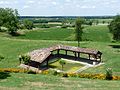
Lavoir at the foot of the village

Saint-Pierre church

War memorial


literature
- Presentation Jean Burias, Le Guide des châteaux de France. 47. Lot-et-Garonne , p. 50-51, Hermé, Paris, 1985, ISBN 2-86665-009-3
Web links
Commons : Loubès-Bernac - Collection of images, videos and audio files