Puysserampion
| Puysserampion | ||
|---|---|---|
|
|
||
| region | Nouvelle-Aquitaine | |
| Department | Lot-et-Garonne | |
| Arrondissement | Marmande | |
| Canton | Le Val du Dropt | |
| Community association | Pays de Lauzun | |
| Coordinates | 44 ° 36 ′ N , 0 ° 19 ′ E | |
| height | 44-116 m | |
| surface | 10.72 km 2 | |
| Residents | 245 (January 1, 2017) | |
| Population density | 23 inhabitants / km 2 | |
| Post Code | 47800 | |
| INSEE code | 47218 | |
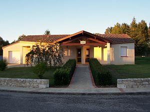
 Mayor's office ( Mairie ) of Puysserampion |
||
Puysserampion is a French municipality with 245 inhabitants (at January 1, 2017) in the department of Lot-et-Garonne in the region Nouvelle-Aquitaine (before 2016: Aquitaine ). The municipality belongs to the arrondissement of Marmande and the canton of Le Val du Dropt (until 2015: canton of Lauzun ).
The name of the municipality is referred to in ancient documents with the Latin name Podio-arrempio . The first part means "mountain". The second part has to be synonymous in the local patois with d'abruptum ( German rugged ). Together this means "rugged mountain".
The inhabitants are called Puysserampionais and Puysserampionaises .
geography
Puysserampion is located about 16 kilometers northeast of Marmande in the historic province of Agenais on the northern edge of the department.
Puysserampion is surrounded by the five neighboring communities:
| Allemans-you-Dropt | Roumagne | |
| Cambes |

|
Miramont-de-Guyenne |
| Peyriere |
Puysserampion is located in the catchment area of the Garonne River .
Tributaries of the Dourdenne cross the territory of the municipality,
- the Ruisseau du Mont Saint-Jean with its tributary,
- the Ruisseau de Lapeyrière, and
- the Ruisseau de Laprade, also called Ruisseau de Junchère.
In addition, the Ruisseau de Pontillou, a tributary of the Ruisseau du Jonquet, has its source in Puysserampion.
history
The municipality was during prehistory , then over the antiquity of Celts and during the era of the Gallo Roman culture populated.
In the 13th century a castle or was Solid house on a hill that overlooks the surrounding area. For centuries away, it belonged to the powerful Goth family. During this time, the French King Philip IV. Bertrand de Goth, Seigneur von Duras , allowed to acquire lands, including those of today's municipalities of Puysserampion, Allemans-du-Dropt and Monségur . This property was inherited by his daughter Géraude de Goth and then by her husband Raymond Lorc.
A legend tells that the castle was the residence of the Templars in the 14th century . This is supported by a letter, which reported that in 1324 the castle of Régine de Goth, Countess of Armagnac and niece of Pope Clement V was one. On April 13, 1312, Clement V ordered the dissolution of the Knights Templar and the transfer of its goods to the Hospitallers . The castle thus came into the hands of the Goth family.
Today there are no traces of the castle left. At one point their building blocks were used to build a farm in the neighborhood.
Population development
After records began, the population rose to a high of around 475 by the first half of the 19th century. In the following period, the size of the community fell to around 165 inhabitants during short recovery periods until the 1970s, before settling at a level between 230 and 260 inhabitants stabilized.
| year | 1962 | 1968 | 1975 | 1982 | 1990 | 1999 | 2006 | 2011 | 2017 |
|---|---|---|---|---|---|---|---|---|---|
| Residents | 256 | 211 | 166 | 244 | 274 | 243 | 233 | 258 | 245 |
Attractions
Parish Church of Saint-Jean-Baptiste. It was placed under the protection of John the Baptist in the 12th or 13th century . Some historians believe that it was built under the influence of the Knights Templar, in view of the massive architecture and the fact that John the Baptist was also the patron saint of the Templars.
Two capitals are left from the Romanesque era. The facade is crowned by a bell gable with three arcades that house the bells. Inside the church, a holy water font and a statue of the Virgin Mary made of gilded wood embellish the nave .
Economy and Infrastructure
Agriculture is one of the most important economic factors in the municipality.

total = 26
education
The municipality has a public primary school with 29 pupils in the 2018/2019 school year.
traffic
Puysserampion can be reached via Routes départementales 132 and 933, the former Route nationale 133 .
Web links
Individual evidence
- ↑ a b c Puysserampion ( fr ) Conseil régional d'Aquitaine. Archived from the original on September 9, 2016. Retrieved on April 11, 2019.
- ↑ Ma commune: Puysserampion ( fr ) Système d'Information sur l'Eau du Bassin Adour Garonne. Retrieved April 11, 2019.
- ↑ Notice Communale Puysserampion ( fr ) EHESS . Retrieved April 11, 2019.
- ↑ Populations légales 2016 Commune de Puysserampion (47218) ( fr ) INSEE . Retrieved April 11, 2019.
- ^ Église Saint-Jean-Baptiste ( fr ) Conseil régional d'Aquitaine. Archived from the original on March 3, 2016. Retrieved April 11, 2019.
- ↑ Caractéristiques des établissements en 2015 Commune de Puysserampion (47218) ( fr ) INSEE . Retrieved April 11, 2019.
- ^ École élémentaire ( fr ) National Ministry of Education. Retrieved April 11, 2019.


