
Auriac-sur-Dropt
|
Auriac-sur-Dropt Auriac de Dròt |
||
|---|---|---|
|
||
| region | Nouvelle-Aquitaine | |
| Department | Lot-et-Garonne | |
| Arrondissement | Marmande | |
| Canton | Les Coteaux de Guyenne | |
| Community association | Communauté de communes du Pays de Duras | |
| Coordinates | 44 ° 39 ′ N , 0 ° 15 ′ E | |
| height | 29-110 m | |
| surface | 5.28 km 2 | |
| Residents | 177 (January 1, 2017) | |
| Population density | 34 inhabitants / km 2 | |
| Post Code | 47120 | |
| INSEE code | 47018 | |
 Auriac-sur-Dropt Council House (September 2015) |
||

Auriac-sur-Dropt is a commune in southwestern France , located in the department of Lot-et-Garonne in the region Nouvelle-Aquitaine (2016: Aquitaine ).
The inhabitants are called Auriacais .
geography
Auriac-sur-Dropt is located in Guyenne in the Côtes de Duras wine-growing region on the Dropt and Route nationale 668 between Moustier and Duras . The community is built up from the districts of Doche, Chapeau Rouge, Clamens, Pierres, Quercy and Pont d'Auriac.
Auriac-sur-Dropt is surrounded by the neighboring communities:
| Duras | ||
.svg)
|
Pardaillan | |
| Saint-Pierre-sur-Dropt | Monteton |
Toponymy
Like the dozen other places in the south-west of the country that have or include the name Auriac, the municipality of Auriac-sur-Dropt takes its name from the Gallic Aurius , followed by the once Celtic suffix -acum , which together means area of Aurius .
In the Occitan regional language, the municipality name is Auriac de Dròt .
Demographics
The population development in Auriac-sur-Dropt has been documented since 1793. With the exception of 2006, statistics were published annually by Insee .
In 2015 the community had 182 inhabitants, which means a decrease of 12.5% compared to 2010.
| year | 1793 | 1800 | 1846 | 1876 | 1901 | 1946 | 1975 | 1999 | 2008 | 2013 | 2017 |
|---|---|---|---|---|---|---|---|---|---|---|---|
| Residents | 410 | 339 | 328 | 334 | 296 | 244 | 227 | 186 | 201 | 188 | 177 |
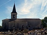
North elevation of the Saint-Martin church (September 2015)

East elevation of the Saint-Martin church (September 2015)
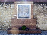
Stele in the church cemetery (September 2015)


Personalities
- Pierre Rosenberg (* 1936) found shelter in the community during World War II