
Cocumont
| Cocumont | ||
|---|---|---|
.svg)
|
|
|
| region | Nouvelle-Aquitaine | |
| Department | Lot-et-Garonne | |
| Arrondissement | Marmande | |
| Canton | Marmande-1 | |
| Community association | Val de Garonne agglomeration | |
| Coordinates | 44 ° 27 ' N , 0 ° 8' E | |
| height | 33-148 m | |
| surface | 25.44 km 2 | |
| Residents | 1,081 (January 1, 2017) | |
| Population density | 42 inhabitants / km 2 | |
| Post Code | 47250 | |
| INSEE code | 47068 | |
 town hall |
||

Cocumont is a French commune with 1,081 inhabitants (at January 1, 2017) in the department of Lot-et-Garonne in the region Nouvelle-Aquitaine .
geography
The municipality of Cocumont lies on the border with the Gironde department , 40 kilometers southeast of Langon and 15 kilometers southwest of Marmande . The inhabitants call themselves "Cocumontais".
Population development
| 1962 | 1968 | 1975 | 1982 | 1990 | 1999 | 2007 |
|---|---|---|---|---|---|---|
| 1140 | 1141 | 1022 | 1022 | 937 | 888 | 941 |
Churches
- Saint Jean-Baptiste church in neo-Gothic style from the 19th century in the village center
- Romanesque church of Saint Jean de Vidailhac from the 11th century
- Church of Gouts, a Romanesque church from the 12th century
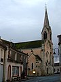
Saint Jean-Baptiste church

Saint Jean de Vidailhac church

Church of Gouts


Economy and Infrastructure
Part of the vineyards of the Côtes du Marmandais is located in Cocumont.
Cocumont is passed by the D3 département road . The next motorway junction is about 11.5 kilometers away on the A62 autoroute . The nearest train station is in Marmande on the Bordeaux - Sète line of the SNCF . It is served by TER Aquitaine trains.
Web links
Commons : Cocumont - collection of images, videos and audio files