
Sainte-Gemme-Martaillac
| Sainte-Gemme-Martaillac | ||
|---|---|---|
|
||
| region | Nouvelle-Aquitaine | |
| Department | Lot-et-Garonne | |
| Arrondissement | Marmande | |
| Canton | Les Forêts de Gascogne | |
| Community association | Coteaux et Landes de Gascogne | |
| Coordinates | 44 ° 22 ′ N , 0 ° 9 ′ E | |
| height | 58-156 m | |
| surface | 14 km 2 | |
| Residents | 411 (January 1, 2017) | |
| Population density | 29 inhabitants / km 2 | |
| Post Code | 47250 | |
| INSEE code | 47244 | |
 Town hall (Mairie) of Sainte-Gemme-Martaillac |
||

Sainte-Gemme-Martaillac ( Occitan : Senta Gema e Martalhac ) is a French municipality with 411 inhabitants (as of January 1 2017) in the department of Lot-et-Garonne in the region Nouvelle-Aquitaine (before 2016: Aquitaine ). The municipality belongs to the arrondissement of Marmande and the canton of Les Forêts de Gascogne (until 2015: canton of Bouglon ). The inhabitants are called Gemmais .
geography
Sainte-Gemme-Martaillac is about 15 kilometers south of Marmande . Neighboring communities of Sainte-Gemme-Martaillac are Sainte-Marthe in the north, Le Mas-d'Agenais in the northeast, Calonges in the east, Leyritz-Moncassin in the south and southeast, Labastide-Castel-Amouroux in the south and southwest and Grézet-Cavagnan in the west .
Population development
| year | 1962 | 1968 | 1975 | 1982 | 1990 | 1999 | 2006 | 2013 |
| Residents | 342 | 359 | 292 | 280 | 308 | 279 | 295 | 379 |
| Source: Cassini and INSEE | ||||||||
Attractions
- Sainte-Gemme church
- Saint-Pierre-ès-Liens church in Martaillac from the 12th century
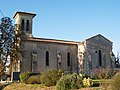
Sainte-Gemme church
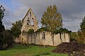
Saint-Pierre-ès-Liens church

