
Leyritz-Moncassin
|
Leyritz-Moncassin Leiritz e Montcassin |
||
|---|---|---|
|
||
| region | Nouvelle-Aquitaine | |
| Department | Lot-et-Garonne | |
| Arrondissement | Nérac | |
| Canton | Les Forêts de Gascogne | |
| Community association | Coteaux et Landes de Gascogne | |
| Coordinates | 44 ° 20 ′ N , 0 ° 10 ′ E | |
| height | 45-175 m | |
| surface | 20.24 km 2 | |
| Residents | 205 (January 1, 2017) | |
| Population density | 10 inhabitants / km 2 | |
| Post Code | 47700 | |
| INSEE code | 47148 | |
 Town hall ( Mairie ) of Leyritz-Moncassin |
||

Leyritz-Moncassin ( Occitan : Leiritz e Montcassin ) is a French municipality with 205 inhabitants (as of January 1 2017) in the department of Lot-et-Garonne in the region Nouvelle-Aquitaine . It belongs to the Arrondissement Nérac and the municipal association Coteaux et Landes de Gascogne, founded in 1996 . The residents call themselves Leyritzais .
geography
Leyritz-Moncassin is located in the Guyenne , 44 kilometers west-northwest of the city of Agen . Neighboring municipalities of Leyritz-Moncassin are Sainte-Gemme-Martaillac in the north, Calonges in the northeast, Razimet in the east and northeast, Puch-d'Agenais in the east, Villefranche-du-Queyran in the east and southeast, Anzex in the south, and La Réunion in the southwest , Casteljaloux in the west and south-west and Labastide-Castel-Amouroux in the west and north-west.
Population development
| year | 1962 | 1968 | 1975 | 1982 | 1990 | 1999 | 2006 | 2011 | 2016 |
| Residents | 284 | 239 | 192 | 208 | 251 | 217 | 204 | 222 | 208 |
| Source: Cassini and INSEE | |||||||||
Attractions
- Notre-Dame-des-Prés church from the 11th / 12th centuries century
- Notre-Dame church in Lussac
- Saint Laurent Church in Moncassin
- Saint-Pierre Church in Leyritz
- Moncassin Castle
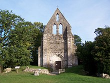
Notre-Dame-des-Prés church

Notre-Dame Church (Lussac)

Saint-Laurent Church (Moncassin)

Saint-Pierre Church (Leyritz)


