
Puch-d'Agenais
|
Puch-d'Agenais Pug d'Agenes |
||
|---|---|---|

|
|
|
| region | Nouvelle-Aquitaine | |
| Department | Lot-et-Garonne | |
| Arrondissement | Nérac | |
| Canton | Lavardac | |
| Community association | Communauté de communes du Confluent et des Coteaux de Prayssas | |
| Coordinates | 44 ° 20 ′ N , 0 ° 15 ′ E | |
| height | 27–123 m | |
| surface | 23 km 2 | |
| Residents | 700 (January 1, 2017) | |
| Population density | 30 inhabitants / km 2 | |
| Post Code | 47160 | |
| INSEE code | 47214 | |
 Town hall (Mairie) of Puch-d'Agenais |
||

Puch-d'Agenais ( Occitan : Pug d'Agenes ) is a community of 700 inhabitants (as of January 1, 2017) in France in the department of Lot-et-Garonne in the region Nouvelle-Aquitaine . The municipality belongs to the Arrondissement of Nérac and the canton of Lavardac . The inhabitants are called Puchois .
geography
Puch-d'Agenais is located about 31 kilometers west-northwest of Agen . Montesquieu is surrounded by the neighboring communities of Razimet in the north and north-west, Villeton in the north-east, Monheurt in the east, Saint-Léger in the south-east, Damazan in the south and south-east, Saint-Léon in the south and Villefranche-du-Queyran in the west and south-west.
The A62 autoroute runs through the municipality .
Population development
| year | 1962 | 1968 | 1975 | 1982 | 1990 | 1999 | 2006 | 2011 | 2016 |
| Residents | 965 | 894 | 742 | 794 | 654 | 651 | 699 | 721 | 703 |
| Source: Cassini and INSEE | |||||||||
Attractions
- Saint-Pierre church in Puch
- Notre-Dame-de-la-Nativité church in Vignes
- Saint-Jean-Baptiste church in Lompian
- Morin Castle
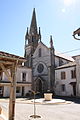
Saint-Pierre church

Notre-Dame-de-la-Nativité church

Saint-Jean-Baptiste church

Morin Castle


