
Poudenas
|
Poudenas Podènas |
||
|---|---|---|
.svg)
|
|
|
| region | Nouvelle-Aquitaine | |
| Department | Lot-et-Garonne | |
| Arrondissement | Nérac | |
| Canton | L'Albret | |
| Community association | Albret Community | |
| Coordinates | 44 ° 3 ' N , 0 ° 13' E | |
| height | 59-162 m | |
| surface | 17.24 km 2 | |
| Residents | 254 (January 1, 2017) | |
| Population density | 15 inhabitants / km 2 | |
| Post Code | 47170 | |
| INSEE code | 47211 | |
 Town hall (Mairie) of Poudenas |
||

Poudenas ( Occitan Podènas ) is a municipality with 254 inhabitants (as of January 1 2017) in France in the department of Lot-et-Garonne in the region Nouvelle-Aquitaine (before 2016 Aquitaine ). The municipality belongs to the Arrondissement of Nérac and the canton of L'Albret (until 2015 Mézin ). The inhabitants are called Poudenaquais .
geography
Poudenas is about 35 kilometers west-southwest of Agen . Poudenas is surrounded by the neighboring communities of Réaup-Lisse in the north, Mézin in the east and northeast, Fourcès in the south and southeast, Montréal in the south, Sainte-Maure-de-Peyriac in the southwest and Sos in the west.
Population development
| year | 1962 | 1968 | 1975 | 1982 | 1990 | 1999 | 2006 | 2017 | |
| Residents | 444 | 347 | 351 | 309 | 274 | 252 | 251 | 254 | |
| Sources: Cassini and INSEE | |||||||||
Attractions
- Saint-Christophe church in Arbussan, historic monument since 1980
- Saint-Antoine church in Poudenas
- Romanesque bridge, rebuilt in 1777
- Poudenas Castle, Monument historique since 1984
- Arcades on the Gélise, former post office
- Bleach mill

Saint-Antoine church
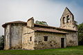
Saint-Christophe Church
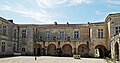
Poudenas Castle

Arcades on the Gélise


Personalities
- Stéphanie de Virieu (1785–1873), painter and sculptor, died at Poudenas Castle
Web links
Commons : Poudenas - collection of images, videos and audio files