
Espiens
| Espiens | ||
|---|---|---|
|
||
| region | Nouvelle-Aquitaine | |
| Department | Lot-et-Garonne | |
| Arrondissement | Nérac | |
| Canton | L'Albret | |
| Community association | Albret Community | |
| Coordinates | 44 ° 10 ′ N , 0 ° 23 ′ E | |
| height | 46-196 m | |
| surface | 17.48 km 2 | |
| Residents | 374 (January 1, 2017) | |
| Population density | 21 inhabitants / km 2 | |
| Post Code | 47600 | |
| INSEE code | 47090 | |

Espiens ( Occitan identical) is a French municipality with 374 inhabitants (as of January 1 2017) in the department of Lot-et-Garonne in the region Nouvelle-Aquitaine (before 2016 Aquitaine ). The municipality belongs to the Arrondissement of Nérac and the canton of L'Albret (until 2015 Nérac ). The inhabitants are called Espiennais .
geography
Espiens is about 22 kilometers west-southwest of Agen . Espiens is surrounded by the neighboring communities of Feugarolles in the north and northwest, Bruch in the north, Montesquieu in the northeast, Montagnac-sur-Auvignon in the east, Calignac in the south and southeast, Nérac in the south and west and Lavardac in the west.
Population development
| year | 1962 | 1968 | 1975 | 1982 | 1990 | 1999 | 2006 | 2017 |
| Residents | 425 | 361 | 327 | 318 | 318 | 310 | 371 | 374 |
| Sources: Cassini and INSEE | ||||||||
Attractions
- Notre-Dame church
- Tower of Espiens
- Mazelières Castle
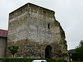
Tower of Espiens

Mazelières Castle


Web links
Commons : Espiens - collection of images, videos and audio files