
Labastide-Castel-Amouroux
|
Labastide-Castel-Amouroux La Bastida de Castèl Amorós |
||
|---|---|---|
|
||
| region | Nouvelle-Aquitaine | |
| Department | Lot-et-Garonne | |
| Arrondissement | Marmande | |
| Canton | Les Forêts de Gascogne | |
| Community association | Coteaux et Landes de Gascogne | |
| Coordinates | 44 ° 20 ′ N , 0 ° 8 ′ E | |
| height | 51-172 m | |
| surface | 11.95 km 2 | |
| Residents | 308 (January 1, 2017) | |
| Population density | 26 inhabitants / km 2 | |
| Post Code | 47250 | |
| INSEE code | 47121 | |
 Town hall (Mairie) of Labastide-Castel-Amouroux |
||

Labastide-Castel-Amouroux ( Occitan : La Bastida de Castèl Amorós ) is a French municipality with 308 inhabitants (as of January 1 2017) in the department of Lot-et-Garonne in the region Nouvelle-Aquitaine (before 2016: Aquitaine ). The municipality belongs to the arrondissement of Marmande and the canton of Les Forêts de Gascogne (until 2015: canton of Bouglon ). The inhabitants are called labastidois .
geography
Labastide-Castel-Amouroux is located about 18 kilometers south-southwest of Marmande . Neighboring municipalities of Labastide-Castel-Amouroux are Grézet-Cavagnan in the north, Sainte-Gemme-Martaillac in the north and northeast, Leyritz-Moncassin in the east, Casteljaloux in the south and southwest and Poussignac in the west.
history
The bastide of Labastide-Castel-Amouroux was founded in 1269.
Population development
| year | 1962 | 1968 | 1975 | 1982 | 1990 | 1999 | 2006 | 2017 |
| Residents | 284 | 237 | 258 | 326 | 296 | 291 | 319 | 308 |
| Sources: Cassini and INSEE | ||||||||
Attractions
- Notre-Dame church in Veyries, originally Romanesque, today's building from the 19th century
- Notre-Dame church ruins in Labastide from the 13th century
- Church ruins Saint-Gény in Cavagnan from the 15th century
- Plantey Castle from the 19th century
- Lacaza Castle

Notre-Dame church in Veyries
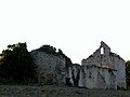
Notre-Dame church ruins in Labastide

Church ruins of Saint-Gény
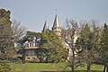
Plantey Castle


