
Montpouillan
|
Montpouillan Montpolhan |
||
|---|---|---|
|
||
| region | Nouvelle-Aquitaine | |
| Department | Lot-et-Garonne | |
| Arrondissement | Marmande | |
| Canton | Marmande-1 | |
| Community association | Val de Garonne agglomeration | |
| Coordinates | 44 ° 28 ′ N , 0 ° 6 ′ E | |
| height | 18-133 m | |
| surface | 12.07 km 2 | |
| Residents | 800 (January 1, 2017) | |
| Population density | 66 inhabitants / km 2 | |
| Post Code | 47200 | |
| INSEE code | 47191 | |
 old town hall (Mairie) of Montpouillan |
||

Montpouillan ( Gascon Montpolhan ) is a French commune of 800 inhabitants (at January 1, 2017) in the department of Lot-et-Garonne in the region Nouvelle-Aquitaine (before 2016 Aquitaine ). The municipality belongs to the arrondissement of Marmande and the canton of Marmande-1 (until 2015 Meilhan-sur-Garonne ). The inhabitants are called Montpouillanais .
geography
Montpouillan is located about seven kilometers southwest of Marmande on the Canal latéral à la Garonne . Montpouillan is surrounded by the neighboring communities Marcellus in the north and west, Gaujac in the north and northeast, Marmande in the east and northeast, Fourques-sur-Garonne in the east, Samazan in the south and southeast, Guérin in the southwest and Cocumont in the west and southwest.
Population development
| 1962 | 1968 | 1975 | 1982 | 1990 | 1999 | 2006 | 2013 | |
|---|---|---|---|---|---|---|---|---|
| 570 | 537 | 521 | 605 | 610 | 557 | 611 | 705 | |
| Source: Cassini and INSEE | ||||||||
Churches
- Saint-Jean church from the 12th century, monument historique
- Saint-Etienne church by Le Sendex
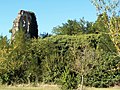
Saint-Jean church

Saint-Etienne church

