
Sainte-Marthe (Lot-et-Garonne)
|
Sainte-Marthe Senta Marta |
||
|---|---|---|
|
||
| region | Nouvelle-Aquitaine | |
| Department | Lot-et-Garonne | |
| Arrondissement | Marmande | |
| Canton | Les Forêts de Gascogne | |
| Community association | Val de Garonne agglomeration | |
| Coordinates | 44 ° 25 ′ N , 0 ° 9 ′ E | |
| height | 28-94 m | |
| surface | 9.65 km 2 | |
| Residents | 605 (January 1, 2017) | |
| Population density | 63 inhabitants / km 2 | |
| Post Code | 47430 | |
| INSEE code | 47253 | |
| Website | http://mairie-saintemarthe.fr/ | |
 Town hall (Mairie) of Sainte-Marthe |
||

Sainte-Marthe ( Gascon Senta Marta ) is a French municipality with 605 inhabitants (at January 1, 2017) in the department of Lot-et-Garonne in the region Nouvelle-Aquitaine (before 2016 Aquitaine ). The municipality belongs to the Arrondissement Marmande and the canton Les Forêts de Gascogne (until 2015 Le Mas-d'Agenais ). The inhabitants are called Saint-Marthais .
geography
Sainte-Marthe is about 75 kilometers south-east of Bordeaux . Sainte-Marthe is surrounded by the neighboring communities of Fourques-sur-Garonne in the north, Caumont-sur-Garonne in the east, Le Mas-d'Agenais in the south-east, Sainte-Gemme-Martaillac and Grézet-Cavagnan in the south, Bouglon in the south-west and Samazan in the west and northwest.
The A62 autoroute runs through the municipality .
Population development
| year | 1962 | 1968 | 1975 | 1982 | 1990 | 1999 | 2006 | 2013 |
| Residents | 393 | 364 | 302 | 306 | 381 | 383 | 460 | 550 |
| Source: Cassini and INSEE | ||||||||
Attractions
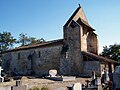
- Sainte-Marthe church from the 11th century
- Saint-Sauveur church from the 17th century
- Lanauze Castle, built from 1751 to 1754, Monument historique since 1978

Sainte-Marthe Church
Saint-Sauveur church

