
Levignac-de-Guyenne
|
Lévignac-de-Guyenne Levinhac de Guiana |
||
|---|---|---|
|
||
| region | Nouvelle-Aquitaine | |
| Department | Lot-et-Garonne | |
| Arrondissement | Marmande | |
| Canton | Les Coteaux de Guyenne | |
| Community association | Pays de Duras | |
| Coordinates | 44 ° 38 ′ N , 0 ° 12 ′ E | |
| height | 32-122 m | |
| surface | 25.02 km 2 | |
| Residents | 663 (January 1, 2017) | |
| Population density | 26 inhabitants / km 2 | |
| Post Code | 47120 | |
| INSEE code | 47147 | |
| Website | http://www.levignac-de-guyenne.com/ | |
 Town hall (Mairie) of Lévignac-de-Guyenne |
||

Lévignac-de-Guyenne ( Occitan : Levinhac de Guiana ) is a French municipality with 663 inhabitants (as of January 1 2017) in the department of Lot-et-Garonne in the region Nouvelle-Aquitaine . It belongs to the arrondissement of Marmande and the canton of Les Coteaux de Guyenne (until 2015: canton of Seyches ). The inhabitants are called Lévignacais .
geography
Lévignac-de-Guyenne is located around 15 kilometers north-northeast of Marmande . Neighboring municipalities of Lévignac-de-Guyenne are Saint-Pierre-sur-Dropt in the north, Monteton in the east, Caubon-Saint-Sauveur in the south, Saint-Géraud in the west and Taillecavat in the northwest.
history
The bastide was founded in 1305.
Population development
| year | 1962 | 1968 | 1975 | 1982 | 1990 | 1999 | 2006 | 2013 |
| Residents | 816 | 726 | 665 | 631 | 652 | 651 | 629 | 612 |
| Source: Cassini and INSEE | ||||||||
Attractions
- 19th century church Saint-Pierre
- Sainte-Croix church from the 13th century

Saint-Pierre church
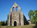
Sainte-Croix church


Personalities
- Léo Melliet (1843–1909), politician and communard
Web links
Commons : Lévignac-de-Guyenne - Collection of images, videos and audio files