
Frontenac (Gironde)
| Frontenac | ||
|---|---|---|
|
||
| region | Nouvelle-Aquitaine | |
| Department | Gironde | |
| Arrondissement | Langon | |
| Canton | L'Entre-deux-Mers | |
| Community association | Rurales de l'Entre-Deux-Mers | |
| Coordinates | 44 ° 44 ′ N , 0 ° 10 ′ W | |
| height | 24-105 m | |
| surface | 14.4 km 2 | |
| Residents | 731 (January 1, 2017) | |
| Population density | 51 inhabitants / km 2 | |
| Post Code | 33760 | |
| INSEE code | 33175 | |
| Website | http://www.frontenac.eu/ | |
 Frontenac Town Hall (Mairie) |
||

Frontenac is a commune with 731 inhabitants (as of January 1 2017) in the Gironde department in the region Nouvelle-Aquitaine (before 2016 Aquitaine ). It belongs to the arrondissement of Langon and the canton of L'Entre-deux-Mers (until 2015 Saint-Macaire ). The inhabitants are called Frontenacais .
geography
Frontenac is located in the southwest of France . North of the municipality is Lugasson , northeast Blasimon , east and southeast Sauveterre-de-Guyenne , south Daubèze , south and southwest Martres , west Baigneaux and northwest Cessac .
Population development
| year | 1962 | 1968 | 1975 | 1982 | 1990 | 1999 | 2008 | 2017 |
| Residents | 624 | 729 | 669 | 640 | 687 | 650 | 694 | 731 |
| Sources: Cassini and INSEE | ||||||||
Attractions
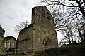
- Notre-Dame church, historic monument since 1925
- Sainte-Présentine church, historic monument since 1987; with baptismal font from the 12th / 13th centuries century
- Commander of the Order of St. John of Sallebruneau, Monument historique since 1937

Notre-Dame church

Saint-Presentine church
Commander


literature
- Le Patrimoine des Communes de la Gironde. Flohic Éditions, Volume 2, Paris 2001, ISBN 2-84234-125-2 , pp. 1534-1535.
Web links
Commons : Frontenac - collection of images, videos and audio files