
Saint-Félix-de-Foncaude
|
Saint-Félix-de-Foncaude Sent Feliç de Font Cauda |
||
|---|---|---|
|
||
| region | Nouvelle-Aquitaine | |
| Department | Gironde | |
| Arrondissement | Langon | |
| Canton | Le Réolais and Les Bastides | |
| Community association | Rurales de l'Entre-Deux-Mers | |
| Coordinates | 44 ° 39 ′ N , 0 ° 6 ′ W | |
| height | 25-86 m | |
| surface | 10.33 km 2 | |
| Residents | 288 (January 1, 2017) | |
| Population density | 28 inhabitants / km 2 | |
| Post Code | 33540 | |
| INSEE code | 33399 | |
 Town hall (Mairie) of Saint-Félix-de-Foncaude |
||

Saint-Félix-de-Foncaude ( Occitan Sent Feliç de Font cauda ) is a French municipality with 288 inhabitants (as of January 1 2017) in the Gironde department in the region Nouvelle-Aquitaine . It belongs to the Arrondissement of Langon and the canton of Le Réolais et Les Bastides .
geography
Saint-Félix-de-Foncaude is about 40 kilometers south-east of Bordeaux . Saint-Félix-de-Foncaude is surrounded by the neighboring communities of Saint-Sulpice-de-Pommiers in the north, Saint-Hilaire-du-Bois in the east and northeast, Camiran in the east and southeast, Saint-Exupéry in the south, Saint-Laurent- du-Bois in the south and southwest and Castelviel in the west.
Population development
| 1962 | 1968 | 1975 | 1982 | 1990 | 1999 | 2006 | 2017 |
|---|---|---|---|---|---|---|---|
| 257 | 258 | 221 | 206 | 244 | 256 | 280 | 288 |
| Sources: Cassini and INSEE | |||||||
Attractions
- Notre-Dame church from the 12th century in Foncaude
- Saint-Félix church from the 12th century in Saint-Félix-de-Pommiers
- Pommiers castle ruins from the 13th century, Monument historique
- Watermill
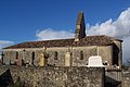
Notre-Dame church

Saint-Félix church

Pommiers castle ruins


literature
- Le Patrimoine des Communes de la Gironde. Flohic Éditions, Volume 2, Paris 2001, ISBN 2-84234-125-2 , pp. 1487–1489.
Web links
Commons : Saint-Félix-de-Foncaude - Collection of images, videos and audio files