
Villandraut
|
Villandraut Vilandraud |
||
|---|---|---|
.svg)
|
|
|
| region | Nouvelle-Aquitaine | |
| Department | Gironde | |
| Arrondissement | Langon | |
| Canton | Le Sud-Gironde | |
| Community association | South Gironde | |
| Coordinates | 44 ° 27 ′ N , 0 ° 22 ′ W | |
| height | 20-54 m | |
| surface | 12.58 km 2 | |
| Residents | 1,059 (January 1, 2017) | |
| Population density | 84 inhabitants / km 2 | |
| Post Code | 33730 | |
| INSEE code | 33547 | |
| Website | http://www.villandraut.fr/ | |
 Town hall (Mairie) of Villandraut |
||

Villandraut ( Occitan : Vilandraud ) is a French municipality with 1059 inhabitants (as of January 1 2017) in the Gironde department in the region Nouvelle-Aquitaine ; it belongs to the arrondissement of Langon and the canton of Le Sud-Gironde . The inhabitants are called Villandrautais .
geography
Villandraut is located about 55 kilometers south-southeast of Bordeaux . Villandraut is surrounded by the neighboring communities of Noaillan in the north, Uzeste in the east, Préchac in the south, Saint-Léger-de-Balson in the west and south-west and Balizac in the west and north-west.
Population development
| year | 1962 | 1968 | 1975 | 1982 | 1990 | 1999 | 2006 | 2013 |
|---|---|---|---|---|---|---|---|---|
| Residents | 988 | 940 | 887 | 914 | 777 | 815 | 900 | 994 |
| Source: Cassini and INSEE | ||||||||
Attractions
- Saint-Martin Church, built between 1850 and 1860
- Villandraut Castle, Monument historique since 1886

Saint Martin Church
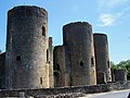
Villandraut Castle


Personalities
- Clemens V (civil: Bertrand de Got, around 1264–1314), Pope
- Robert Boulin (1920–1979), politician, a. a. Minister of Agriculture (1968/1969)
literature
- Le Patrimoine des Communes de la Gironde. Flohic Éditions, Volume 2, Paris 2001, ISBN 2-84234-125-2 , pp. 1587–1595.
Web links
Commons : Villandraut - collection of images, videos and audio files