
Préchac (Gironde)
| Préchac | ||
|---|---|---|
.svg)
|
|
|
| region | Nouvelle-Aquitaine | |
| Department | Gironde | |
| Arrondissement | Langon | |
| Canton | Le Sud-Gironde | |
| Community association | South Gironde | |
| Coordinates | 44 ° 24 ′ N , 0 ° 21 ′ W | |
| height | 26-93 m | |
| surface | 63.73 km 2 | |
| Residents | 1,010 (January 1, 2017) | |
| Population density | 16 inhabitants / km 2 | |
| Post Code | 33730 | |
| INSEE code | 33336 | |
| Website | http://www.sprechac.fr/ | |
 Town hall (Mairie) of Préchac |
||

Préchac is a French commune with 1,010 inhabitants (as of January 1 2017) in the Gironde department in the region Nouvelle-Aquitaine ; it belongs to the arrondissement of Langon and the canton of Le Sud-Gironde . The inhabitants are called Préchacais .
geography
Préchac is about 49 kilometers south-southeast of Bordeaux . Préchac is surrounded by the neighboring communities of Villandraut in the north, Uzeste in the north and northeast, Pompéjac in the east, Lucmau in the southeast, Cazalis in the south, Boundeys in the west and southwest and Saint-Léger-de-Balson in the west and northwest.
Population development
| year | 1962 | 1968 | 1975 | 1982 | 1990 | 1999 | 2006 | 2013 |
|---|---|---|---|---|---|---|---|---|
| Residents | 1,136 | 1,050 | 1.007 | 953 | 985 | 1,017 | 1.011 | 1,046 |
| Source: Cassini and INSEE | ||||||||
Attractions
- Saint-Pierre-ès-Liens church, monument historique since 1909
- Church of Saint Martin of Insos, a historic monument since 1925
- Cazeneuve Castle, monument historique since 1965
- La Trave fortress ruins, a historic monument since 1987
- La Fue Castle ruins (also: La Travette Castle), Monument historique since 1987
See also: List of Monuments historiques in Préchac (Gironde)

Saint-Pierre-és-Liens church

Saint Martin Church

Cazeneuve Castle
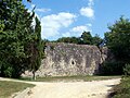
La Trave fortress ruins


literature
- Le Patrimoine des Communes de la Gironde. Flohic Éditions, Volume 2, Paris 2001, ISBN 2-84234-125-2 , pp. 1570-1571.
Web links
Commons : Préchac - collection of images, videos and audio files