Bagas
| Bagas | ||
|---|---|---|
|
|
||
| region | Nouvelle-Aquitaine | |
| Department | Gironde | |
| Arrondissement | Langon | |
| Canton | Le Réolais and Les Bastides | |
| Community association | Réolais en Sud Gironde | |
| Coordinates | 44 ° 37 ′ N , 0 ° 3 ′ W | |
| height | 11-86 m | |
| surface | 3.63 km 2 | |
| Residents | 295 (January 1, 2017) | |
| Population density | 81 inhabitants / km 2 | |
| Post Code | 33190 | |
| INSEE code | 33024 | |
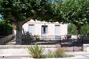
 Mairie Bagas |
||
Bagas is a French commune of 295 inhabitants (at January 1, 2017) in the Gironde department in the region Nouvelle-Aquitaine . Their inhabitants are called Bagassons .
geography
Bagas lies in the lowlands of the 133-kilometer-long Dropt , which also forms the northern border and flows into the Garonne about eight kilometers southwest . About six kilometers south is Langon , which also has its own train station. Today the two-lane D 670 runs on the eastern edge of the village, which until a few years ago operated as the national road 670 . Originally it ran over the old bridge through the town. At the end of the 1990s, a new development area with around 30 building sites was developed south of the previous town center.
history
The core of the village is probably the Bagas fortified mill from the 11th century, which was listed as a historical monument in 1926 . The slightly elevated Notre-Dame church from the 12th century was built on a former Roman villa. The wash house is also worth seeing .
Population development
| year | 1962 | 1968 | 1975 | 1982 | 1990 | 1999 | 2006 | 2017 |
| Residents | 202 | 200 | 197 | 158 | 144 | 173 | 201 | 295 |
Architectural monuments
See: List of Monuments historiques in Bagas
literature
- Le Patrimoine des Communes de la Gironde. Flohic Éditions, Volume 2, Paris 2001, ISBN 2-84234-125-2 , pp. 1201-1202.


