Bellevue, Nebraska
| Bellevue | |
|---|---|
|
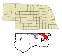
Location in Nebraska
|
|
| Basic data | |
| Foundation : | 1822 (1855) |
| State : | United States |
| State : | Nebraska |
| County : | Sarpy County |
| Coordinates : | 41 ° 9 ′ N , 95 ° 55 ′ W |
| Time zone : | Central ( UTC − 6 / −5 ) |
| Residents : | 55,505 (as of 2016) |
| Population density : | 1,613.5 inhabitants per km 2 |
| Area : | 34.7 km 2 (approx. 13 mi 2 ) of which 34.4 km 2 (approx. 13 mi 2 ) is land |
| Height : | 315 m |
| Postcodes : | 68005, 68123, 68147 |
| Area code : | +1 402 |
| FIPS : | 31-03950 |
| GNIS ID : | 0827304 |
| Website : | www.bellevue.net |
| Mayor : | Rusty hike |
Bellevue is located in the US state of Nebraska in Sarpy County . It is the oldest and third largest city in the entire state.
Demographics
According to the United States Census 2010 , Bellevue has 50,137 residents.
location
The city is located directly on the Nebraska- Iowa border and only approx. 12 km south of Omaha . The Nebraska State Route 370 runs east-west through the city.
history
Bellevue grew out of a fur trading post established in 1822 by the Missouri Fur Company . It got its name from the first settlers, who were impressed by the beautiful view (French: "belle vue") over the Missouri River . In the 1850s, Bellevue experienced a building boom that saw the construction of a Presbyterian church , hotel, bank and private apartments. On February 23, 1855, Bellevue officially became a self-governing city. But since Omaha was raised to the capital of the area, Bellevue's population fell again. It was not until Bellevue College was founded in the 1880s and Fort Crook was completed by the United States Army in 1896 that its existence was secured. In 1921 Fort Crook was expanded to include an airfield and in 1924 it was renamed Offutt Field . In 1948 it became Offutt Air Force Base and ensured work in the region. From 1940 to 1970, Bellevue's population rose from 1,200 to over 20,000.
