Berger Kogel
| Berger Kogel | ||
|---|---|---|
|
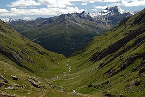
View over the Timmeltal to the Berger Kogel. To the right of it the Lasörling |
||
| height | 2656 m above sea level A. | |
| location | East Tyrol , Austria | |
| Mountains | Lasörling group , Venediger group | |
| Coordinates | 46 ° 59 ′ 40 " N , 12 ° 22 ′ 56" E | |
|
|
||
| First ascent | unknown | |
| Normal way | From Losach to the Bergerseehütte and via the west climb (not difficult ) | |
The Berger Kogel , also Bergerkogel , is 2656 m above sea level. A. high mountain peaks of the Lasörling Group in the Lasörling Group ( Venediger Group ) in East Tyrol ( Austria ). It is located in the northwest of East Tyrol in the municipality of Virgen . The Berger Kogel is a comparatively simple, rewarding mountain with a view.
location
The Berger Kogel is located in the north of the Lasörling Group and has a short north and south-east ridge, while the longer south-west ridge leads to the Bergeralmscharte ( 2500 m above sea level ). The Bergeralmscharte separates the Berger Kogel from the neighboring Seiche ( 2795 m above sea level ). Furthermore, to the east is the insignificant Bläß ( 2225 m above sea level ). The north flank of the Berger Kogel falls into the Virgental and houses the Berger Alm. The west flank leads into the valley of the Zopatnitzenbach , at the end of which is the Bergerseehütte and the Berger See . The Berger Bach rises on the eastern flank or the so-called Kogelmähder .
Promotion opportunities
The technically easiest ascent option is from the Losach district (municipality of Prägraten am Großvenediger ). Here the path leads along the Zopanitzenbach to the Bergerseehütte, from where the ascent to the east initially leads over grassy slopes under the north-west slopes of the Seiche. From the Bergeralmscharte the final ascent leads north over a grass slope to the summit cross. A slightly shorter variant leads from Wallhorn or Welzelach to the Berger Alm and along the northern slope of the Berger Kogel to the Wetterkreuz ( 2153 m above sea level ). The final ascent takes place on the northwest ridge to the summit ( I ).
Individual evidence
literature
- Willi End / Hubert Peterka : Alpine Club Leader Venediger Group ; Bergverlag Rudolf Rother ; 4th edition 1994; ISBN 3-7633-1242-0 ; P. 522
- Walter Mair: East Tyrolean hiking book. 700 hikes between the Hohe Tauern and the Carnic Alps, the Grossglockner and the Lienz Dolomites ; Tyrolia Publishing House; 8th edition 2013; ISBN 978-3-7022-1681-8
Web links
- Tour description on tourenfex.at

