
Bernitz (Upper Franconia)

The Bernitz describes an approximately 400 hectare plateau in Franconian Switzerland in the administrative region of Upper Franconia .
geography
The area is just under two kilometers southeast of Pottenstein and extends to Elbersberg . The ridge lies between 450 and 485 meters above sea level and is bordered to the north by the Püttlach valley, which is deeply indented into the Franconian Jura . To the west, the terrain drops steeply over 70 meters in altitude to the valley of the Weihersbach, which feeds the Schöngrund reservoir there. The highest peaks reach almost 500 meters above sea level .
The Bernitz plateau can be reached from federal highway 470 via a steep municipal road in serpentines . From Pottenstein a local road leads through it, but from the Finkenleite to Elbersberg it is only gravel and is single-lane. Numerous unpaved forest roads open up the area for agricultural purposes.
history

The numerous karst caves in the area probably offered protection and shelter in the pre-ice age. To the west, directly below the Bernitz, is the entrance to the Teufelshöhle , in which u. a. the full skeleton of a cave bear was excavated. The bears also gave the Bernitz its name, short for: there where the bears sit . The area was long uninhabited. Significant historical horizons began in the Carolingian period. In the Middle Ages, the area was increasingly used for agriculture and fishing. There are atonement and way crosses, martyrs and small field chapels. By 1800 Pottenstein and Elbersberg, which was also called Bernitz at the time, had almost reached their present-day area.
Bernitz camp
In autumn 1942, the training company of the SS Karstwehr under the leadership of Hans Brand was stationed on the Bernitz , and camp barracks for 600 recruits were built. Up to 700 forced laborers were used for the construction work . 300 of these "prisoners" from all over Europe were initially housed in a heated barn in Pottenstein, which was considered a satellite camp of the Flossenbürg concentration camp east of Nuremberg.
Outside the camp, horse stables and the Schöngrundsee (as a "water exercise facility", see overview picture on the right) were built, changes were made around and in the Teufelshöhle, roads were built.
When fully expanded, the Bernitz camp included a parade ground and sports field, 16 shooting ranges, including 3 sniper tracks, a total of 27 buildings, including 10 team barracks of 500 m² as well as stables for 350 horses, halls for 100 vehicles, 5 climbing gardens, 6 caves and 2 mining shafts. Stables were also used in the neighboring villages. From August 1943, units from the Bernitz were relocated to Carinthia , and from November 1943 to Italy and Slovenia . In the period that followed, the camp changed from a training location to a prison camp. The supply situation there was considered to be comparatively good. At the end of the war there was a shortage of ammunition and fuel.
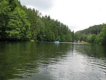
Schöngrund reservoir

Barrack camp of the SS Karstwehr training company, Bernitz, 1942

Kitchen of the Bernitz camp, 1944
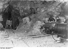
Entrenchment works by the SS Karstwehr training company Bernitz, 1942
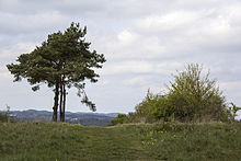
The Bernitz plateau


In mid-April 1945 the camp came under fire from American forces from the south, and a Polish medic was fatally injured. The SS men fled. The prisoners were released and initially set off in the direction of Nuremberg, but after several hours they returned to the camp and initially looted the facilities on the Bernitz together with local residents, also stealing weapons.
Subsequently, the local gendarmerie master was arrested and spent several months in an internment camp; meanwhile, his family committed suicide out of desperation.
Some of the former camp inmates stayed at the site even after the war ended, and founded a new business in Pottenstein and Pegnitz, for example.
today
Flora and fauna have long since recaptured the Bernitzhöhe. The site is freely accessible all year round and is designated as a nature reserve Franconian Switzerland - Veldenstein Forest in the administrative region of Upper Franconia.
Today nothing can be seen of the former storage facilities. There is no memorial; a memorial plaque near the Devil's Cave was controversial in 1961 and then removed. Only the lean barn in Pottenstein is still preserved today and is listed under object number: D-4-72-179-108 monument protection . There are sporadic information evenings on the history of the former facilities on the Bernitz, their inventory and the surrounding area.
Web links
- Video of the media workshop in Franconia , (awarded the television prize of the Bavarian State Media Center in 1992).
Individual evidence
- ^ Karst weir, cave exploration
- ↑ Contemporary witness report on the Bernitz camp
- ↑ Press report Magerscheune
- ↑ Information about the Bernitz camp on a private webpage with photos
Coordinates: 49 ° 45 ′ 34.9 " N , 11 ° 25 ′ 20.6" E